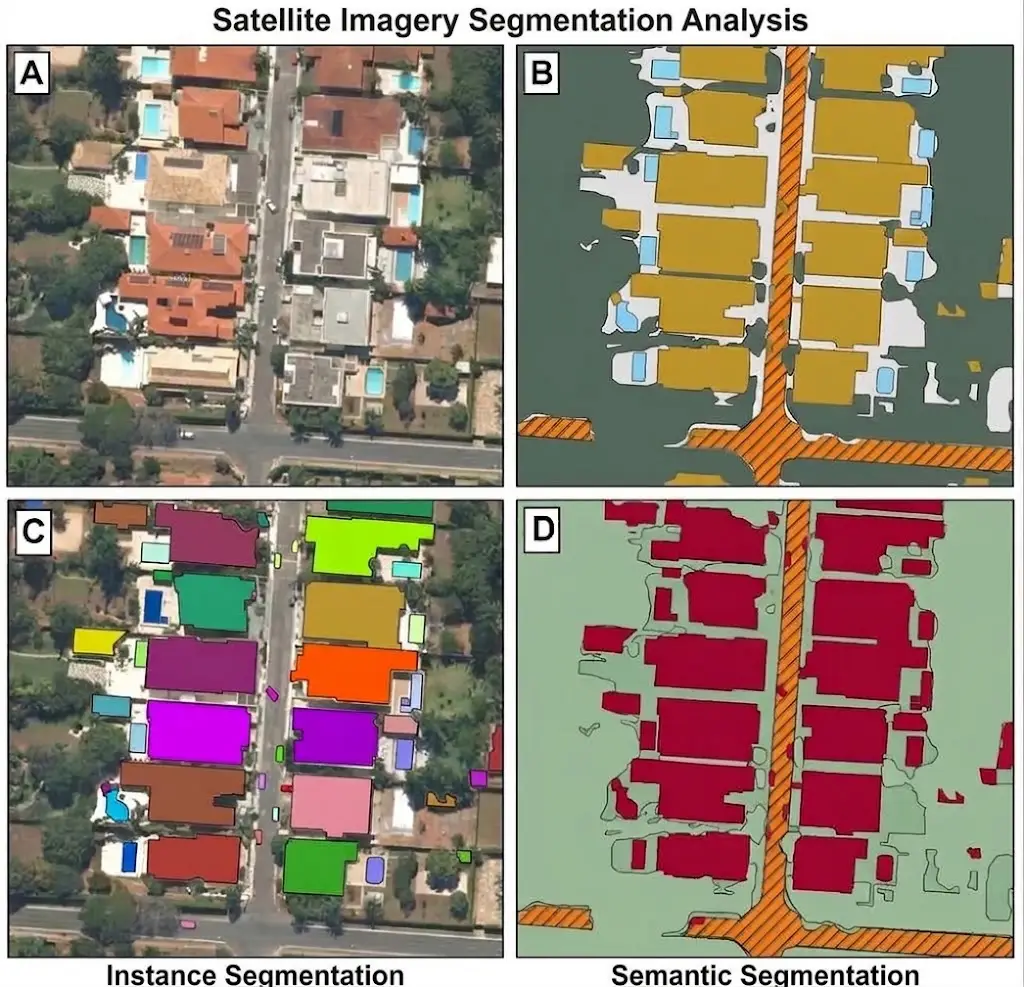
The overhead view removes occlusion and replaces it with a more stubborn difficulty: the boundaries you are asked to trace rarely correspond to a visible discontinuity, because they separate land uses rather than objects.This article sets out what this context demands. It extends the article on medical image segmentation.
What distinguishes this context
Five properties separate this image segmentation vertical from the others.Continuous materials dominate, an image holding few countable objects.Scale varies strongly, one corpus being able to mix resolutions with no relation to each other.The view is overhead, which removes the mutual occlusion of objects.Boundaries belong to a use rather than to a material, a parcel limit crossing a homogeneous cover.And the image often carries far more bands than the three of the visible range.One important practical consequence follows. The fourth property is the most decisive, part of the boundaries requested not existing in the signal and coming from an administrative or functional reality.The boundaries the image does not carry
This difficulty dominates the vertical and it is irreducible.Four situations illustrate it in image segmentation.A parcel limit crossing a field cultivated in a uniform way.A boundary between two land uses identical in appearance, residential and mixed notably.A progressive transition between two covers, a woodland edge or a wetland.And an administrative limit with no physical translation on the ground.One important observation follows for an image segmentation project. Those four situations call for an external source rather than a more attentive examination, the information needed not being in the image.What scale changes
Four effects follow from the variation in resolution in image segmentation.One category appears as an object or as a texture according to the resolution.The minimum size threshold does not carry the same meaning from one image to another.Boundary length grows with fineness, and so does the workload.And a corpus mixing resolutions produces a variable precision requirement with nothing to explain it.One practical consequence follows. Those four effects require expressing thresholds in ground units rather than in pixels, a threshold in square metres keeping its meaning where a threshold in pixels changes with the resolution.What the spectral bands bring
Three observations situate this particularity in image segmentation.Some distinctions invisible in natural colours become obvious on other bands.The annotator must have several colour compositions and know which to consult for each class.And a boundary traced on one composition does not necessarily coincide with the one another would suggest.One important practical consequence follows. The third finding requires declaring which composition the boundary was traced on, information nobody records and which explains part of the disagreement between annotators.The land cover nomenclatures
A particularity of this image segmentation vertical deserves stating.The categories come from references established by the field’s own bodies.Three consequences follow.The nomenclature is not written, it is adopted, as in the medical context.The categories are hierarchical, a level of detail having to be chosen explicitly.And the definitions often carry quantified thresholds, a cover rate or a minimum area.One observation follows for an image segmentation project. The third point is valuable, a reference that quantifies its thresholds supplying a convention most other domains ask you to invent.Clouds and shadows
Four recurring situations call for an explicit image segmentation rule.The opaque cloud, which entirely masks the ground.The thin veil, which alters the colours without masking the structure.A cloud’s cast shadow, which darkens an otherwise visible zone.And a shadow from relief or buildings, which belongs to the ground and not to the object casting it.One practical consequence follows. The second situation is the most problematic, a thin veil leaving annotation possible while biasing the colour criteria, which produces a classification that is consistent and wrong.What the season imposes
A temporal property directly affects this vertical.Three consequences follow in image segmentation.One parcel changes appearance entirely with the period, without changing use.A corpus built on a single season does not prepare a system for the others.And comparison between two dates presupposes an equivalent season or else an explicit correction.One important observation follows. The first consequence produces a direct annotation difficulty, an annotator having to classify a use from an appearance that is only one of its seasonal manifestations.The external sources and their use
A practice specific to this vertical deserves setting out.External data supplies the boundaries the image does not carry.Four external sources occur in satellite image segmentation.The cadastre or the parcel register, which gives the limits of ownership and of farming.Existing land cover databases, to be updated rather than recreated.Field surveys, expensive and irreplaceable on the ambiguous classes.And data from another sensor, radar or altimetric, which lifts certain confusions.One important practical consequence follows. The second source changes the nature of the work, an update consisting in detecting and correcting the changes rather than retracing everything, which divides the load across the stable zones.What quality control exploits
Five image segmentation verifications suit this vertical.The proportion of each class per image, whose aberrant value signals a confusion.Neighbourhood consistency, certain classes never abutting in reality.Continuity at tile edges, two neighbouring tiles having to agree.Comparison with an external source where one exists, cadastre or parcel register.And verification of the zones under thin veil, whose classification stays the most suspect.One important observation follows for an image segmentation project. The third verification is specific to this vertical, an image divided into tiles for annotation systematically producing discontinuities at the joins that nothing else reveals.The control by external comparison
A verification specific to this vertical deserves setting out.An existing database supplies a reference independent of the work carried out.Three uses follow in image segmentation.Detecting large divergences, which signal either an error or a real change on the ground.Verifying areas per class, which reveals a nomenclature drift.And checking parcel limits, which must coincide with the source where it served as reference.One practical consequence follows. The first use produces information with two meanings, a divergence being either a finding of error or a detection of change, which makes it a control and a deliverable according to the project’s purpose.Dividing into tiles
A practical constraint structures production on this vertical.A satellite image far exceeds what a tool can display.Four consequences follow.The image is divided into tiles, each constituting one task.An object straddling two tiles is annotated twice, independently.The annotator lacks context, an isolated tile not showing the overall structure.And the join between tiles produces discontinuities clearly visible on assembly.One important practical consequence follows. The third effect is the most underestimated, a land use often being recognised by its overall organisation rather than by its local texture, which makes overlap between tiles necessary rather than comfortable.The classes that get confused
Five confusions recur in the image segmentation corpora of this vertical.Grassland and forage crop, distinguished by a use rather than by an appearance.Bare agricultural soil and artificialised soil awaiting construction.Wasteland and natural zone, whose limit depends on an invisible duration of abandonment.Industrial and commercial buildings, identical seen from above.And roadway and car park, which share the same surfacing.One important observation follows for an image segmentation project. Those five confusions share a common structure, the distinction resting on a function the overhead view does not show, which makes them irreducible without an external source and justifies treating them explicitly in the reference.What this work costs
Four factors determine the image segmentation load on this vertical.The cumulative length of the boundaries, which grows with the fineness of the nomenclature.The hierarchical level adopted, each additional level multiplying the decisions.The proportion of boundaries with no visible translation, which requires an external source.And the area covered, the only variable clients consider spontaneously.One observation follows. The second factor produces the largest variation, moving from a general level to a detailed one multiplying the number of boundaries far beyond what the class count suggests.What assistance brings here
Three observations situate automatic help on this vertical.Classification by spectral similarity works well on homogeneous covers.Designation by clicking serves little, continuous materials having no contour to designate.And use boundaries stay entirely human, no signal in the image carrying them.One practical consequence follows for an image segmentation project. The first finding separates this vertical from the medical context, spectral similarity being far more effective here since the classes are partly defined by their signature.What the training must cover
Five competences distinguish an annotator trained on this image segmentation vertical.Reading the different colour compositions and choosing the one suited to the class handled.Recognising a land use from its organisation rather than from its texture alone.Identifying thin veils and cast shadows, which call for flagging.Consulting the external source where the boundary belongs to a use.And knowing the nomenclature reference, including its quantified thresholds.One practical consequence follows. The second competence is the hardest to acquire, it presupposes a familiarity with the territory that reading images alone does not provide, which argues for stable teams on one type of terrain.What comparison between dates requires
A frequent use of these corpora imposes additional conditions.Detecting a change presupposes that what has not changed appears identical.Four conditions must be met for an image segmentation corpus.Precise geometric registration, a shift of a few pixels producing a false change on every boundary.A comparable season, the difference in appearance between two periods often exceeding the real change.An identical nomenclature, an evolution of the reference reading as a change on the ground.And a stable placement convention, a contour traced differently producing a fictitious variation in area.One important observation follows. The fourth condition is the most discreet, a change of rule between two campaigns producing a measured change that corresponds to nothing on the ground.The uses that govern
Five purposes occur on this image segmentation vertical, and they do not call for the same fineness.Monitoring land take, which needs a few general classes and a comparison between dates.Agricultural monitoring, which needs parcel limits and therefore an external source.Forest mapping, which needs species or structures and pushes the nomenclature far.Change detection, which needs temporal consistency more than fineness.And preparing a model, which needs diversity of conditions more than exhaustiveness.One observation follows for an image segmentation project. The fourth purpose is satisfied by a coarse nomenclature applied rigorously, which makes it markedly cheaper than the others while it is often costed like them.The pilot batch on this vertical
Four tiles compose a pilot batch suited to this image segmentation vertical.A tile of homogeneous cover, which supplies the reference throughput and tests spectral similarity.A tile crossed by a use limit with no visible translation, which verifies the external source is accessible and usable.A tile in a heterogeneous zone, peri-urban notably, which measures the dominant cost factor.And a tile containing a thin veil or a cloud shadow, which tests the flagging instruction.One observation follows. The second tile frequently reveals an organisational problem rather than an annotation one, the external source being assumed available and proving obsolete, incomplete or in a different geographic reference.What the corpus must declare
Six pieces of information accompany an image segmentation delivery on this vertical.The nomenclature reference and the hierarchical level adopted.The resolution of each image and the unit in which the thresholds are expressed.The colour composition on which the boundaries were traced.The external sources used, with their date of validity.The acquisition period, indispensable to any later comparison.And the mask of cloudy or veiled zones, to be distinguished from the simply unannotated ones.One practical consequence follows. The fourth is the one whose absence is paid latest, a boundary from an obsolete source appearing as reliable as an observed one while nothing in the corpus distinguishes them.Approaching a satellite project
Five questions scope a satellite image segmentation project.Which nomenclature reference applies and at what level. That answer determines the load.Which boundaries belong to a use rather than a material. They call for an external source.Does the corpus mix resolutions. A positive answer requires thresholds in ground units.Which seasons are represented. That answer bounds generalisation.And is overlap between tiles planned. Its absence produces discontinuities at the joins.Those five answers determine feasibility and cost. Asking them before starting avoids a corpus whose administrative boundaries were guessed.The question that frames the project
One question determines the load of a satellite project.Do the boundaries requested separate materials or uses.A materials-oriented answer, vegetation cover, water or mineral surface, places the project in the regime where the image suffices and where spectral similarity accelerates.A use-oriented answer, parcels, designations or functional categories, requires an external source and makes the work dependent on its availability and its freshness.That question is asked in one sentence, it belongs to the reference and not to the technique, and it predicts cost and risk better than the area to cover.Three decisions before the first tile
Three decisions commit a satellite image segmentation project.Choosing the nomenclature reference and its hierarchical level, which determines the load more than the area does.Listing the boundaries that belong to a use and verifying the external source exists, is current and overlays correctly.And expressing every threshold in ground units, which makes them valid across a multi-resolution corpus.Those three decisions cost a few days of preparation, they precede the first tile, and their absence produces a corpus part of whose boundaries were guessed with nothing to signal it.What this vertical brings to the others
Three practices born here hold beyond satellite imaging.Expressing thresholds in world units rather than in pixels, applicable anywhere resolution varies between acquisitions.Using a declared external source for the boundaries the image does not carry, transferable as soon as a category belongs to a function rather than an appearance.And overlap between work units, necessary whenever a division deprives the annotator of context.One observation follows. Those three practices answer one same situation, that where the display unit does not coincide with the unit of meaning, a configuration this vertical makes obvious and that other domains endure without formulating it.What this chapter leaves to the next
One vertical inverts every property set out here.Autonomous driving observes the scene from the ground and in motion.Three differences follow.Occlusion becomes the dominant difficulty again, one object permanently masking another.Countable objects count as much as continuous materials, which requires the combined formulation.And the scene scrolls past, which adds a requirement of consistency between successive images.Those three differences make this vertical the context where exhaustiveness and counting are imposed together, and they constitute the subject of the following chapter.What this chapter teaches
One cross-cutting observation deserves closing this examination.This vertical asks for limits the image does not contain to be traced.Three findings compose it.Part of the boundaries separates uses rather than materials, which calls for an external source and not a more attentive examination.The nomenclature reference pre-exists and often quantifies its thresholds, which supplies a convention other domains must invent.And dividing into tiles deprives the annotator of the context on which identifying a use depends.That finding forms a counterpoint to the preceding chapter, the limit coming here from the data where it came from expert judgement.The dependency worth naming in a proposal
One risk on this vertical belongs to neither party and is best raised early.A project resting on external sources inherits their state.Three failures follow in image segmentation.The source is older than the imagery, so it describes a ground that has since changed.The source is incomplete over part of the area, which leaves boundaries with nothing to derive them from.And the source sits in a different geographic reference, so it overlays with a shift nobody notices until the joins are examined.One practical consequence follows for an image segmentation provider. Naming this dependency in the proposal, with what happens to the schedule if the source proves unusable, converts a likely mid-project dispute into a clause both parties agreed to, and it costs one paragraph.Common mistakes
These failures recur often enough that naming them is usually enough to avoid them.- Expressing a size threshold in pixels on a multi-resolution corpus.
- Writing a nomenclature instead of adopting a reference from the field.
- Not choosing the hierarchical level explicitly.
- Asking for a use limit to be traced with no external source supplied.
- Annotating under a thin veil without flagging it.
- Building a corpus on a single season.
- Dividing into tiles with no overlap.
- Neglecting the continuity check at the joins.
- Omitting to declare the colour composition used.
- Costing by area covered without considering nomenclature fineness.