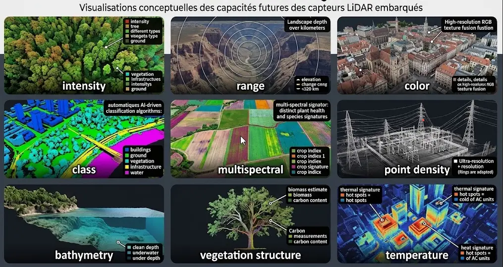
Aerial LiDAR measures a geometry and imagery describes an appearance. Those two pieces of information are complementary rather than redundant, and their combination permits distinctions neither produces alone.This article sets out the possible arrangements, what each brings and the difficulties the combination introduces. It extends the article on point density.
What each modality brings
This complementarity founds every arrangement that follows.It deserves stating precisely.Aerial LiDAR brings three-dimensional position, vertical structure and measurement of the ground under canopy, information no passive imagery supplies.Imagery brings colour, texture and spectral response, information geometry does not contain.Three distinctions illustrate that complementarity.A flat roof and a parking area present identical geometry and different appearance.Two forest species of similar height present close geometry and distinct spectral signature.And a lawn and a green roof present similar appearance and opposite vertical position.One important observation follows. Those three cases are not exceptions but common configurations, which makes the combination useful in most projects rather than in a few special cases.Colourising a cloud
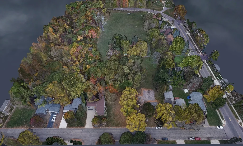
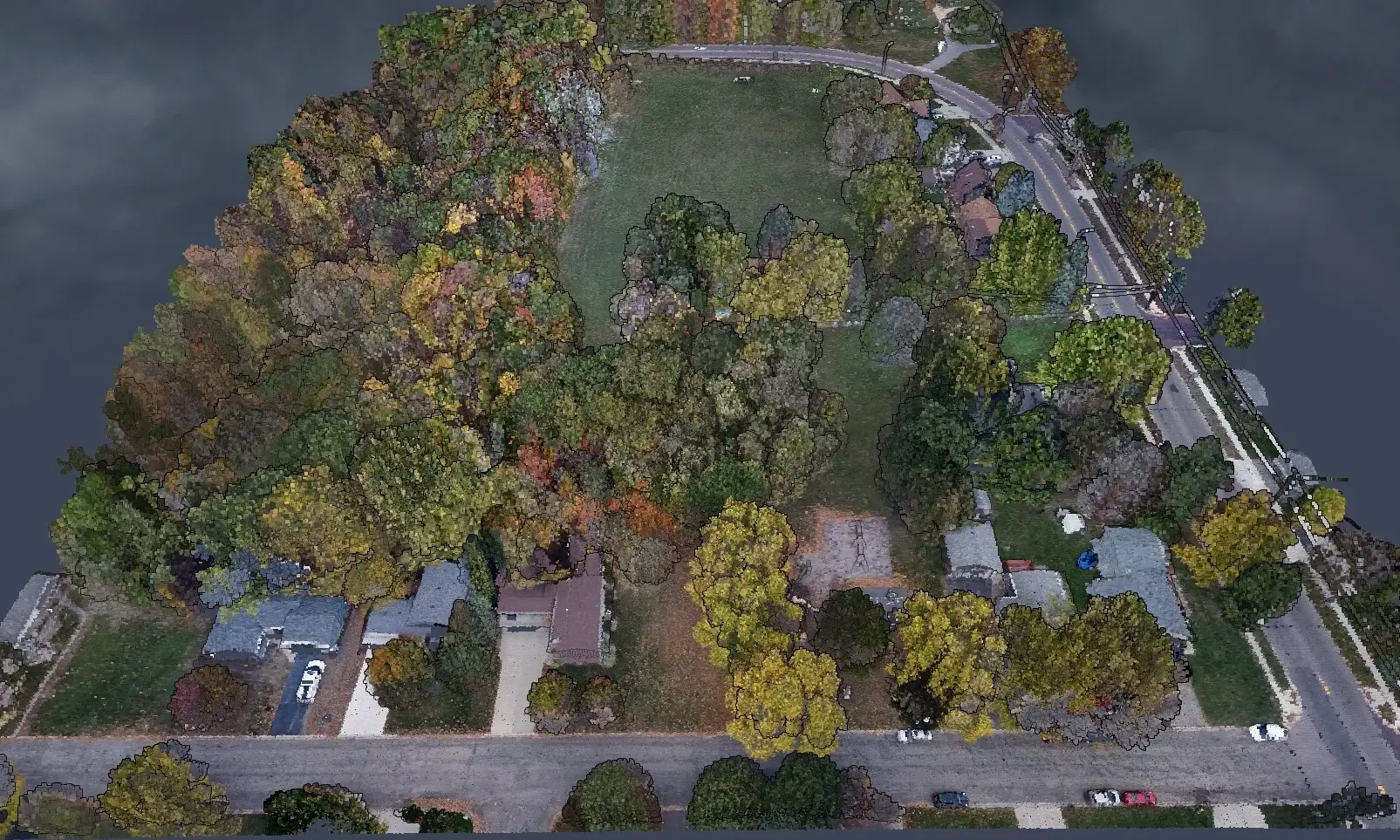
This is the simplest and commonest arrangement in aerial LiDAR.It deserves describing first.The principle is to assign each point the colour of the corresponding pixel in an orthorectified image.Three benefits follow.Annotation becomes more intuitive, an annotator recognising objects by appearance as much as by form.Communication improves, a colourised cloud being immediately legible to a non-specialist.And certain distinctions become possible, surface nature completing the geometry.Three precautions nonetheless frame it.Temporal coincidence matters, an image acquired at another date assigning colours to objects that have changed.Registration must be verified, an offset systematically assigning the neighbour’s colour.And vertical surfaces receive unreliable colour, a nadir image describing facades poorly.The acquisition arrangements
Three configurations produce combinable data.Their constraints differ markedly.Simultaneous acquisition carries both sensors on the same platform, which guarantees temporal coincidence and a common georeferencing, and constitutes the most favourable configuration.Close acquisition uses two distinct flights days apart, which preserves comparability for most uses and introduces registration work.And combining independent sources associates a national survey with available imagery, the most economical configuration and the most demanding in harmonisation.One important observation follows for an aerial LiDAR project. That third configuration is by far the most frequent in practice, public programmes supplying the two sources separately, and it requires explicitly handling discrepancies of date, resolution and georeferencing.Registration between sources
This operation conditions everything that follows.Its omission produces systematic errors in aerial LiDAR.Two separately acquired sources never coincide exactly, each carrying its own georeferencing errors.Three manifestations reveal a registration defect.Colour systematically offset on one side of objects, roofs receiving the colour of the adjacent street for instance.Misaligned object edges, a building outline from the imagery not coinciding with the one from the cloud.And shadows assigned to the wrong surface, a cast shadow colourising the adjacent ground rather than the object projecting it.One practical consequence follows. Verifying registration on a few buildings before any exploitation takes minutes, and its omission produces an error propagating through the whole treatment and which nothing subsequently signals.The levels of fusion
Three approaches combine the two sources.They do not intervene at the same point in the chain.Data-level fusion assigns spectral values to each point, producing an enriched cloud subsequent processing exploits as a single source. It is simple and it presupposes strict geometric coincidence.Feature-level fusion computes descriptors on each source separately, height and roughness on one side, spectral indices on the other, then combines them as input to a classification. It tolerates resolution discrepancies better.And decision-level fusion classifies each source independently then combines the results under a priority rule. It tolerates date discrepancies and it loses the interactions between modalities.One important observation follows for an aerial LiDAR project. The second approach is the best compromise in most cases, it exploits both sources without requiring the strict coincidence the first demands, and it preserves the interactions the third loses.The uses of the combination
Five applications genuinely exploit this complementarity.They justify the harmonisation effort.Identifying forest species, geometry distinguishing the broad families and the spectrum separating the species.Characterising urban surfaces, geometry identifying a roof and the spectrum determining its material.Mapping impermeability, which requires both the surface and its nature.Enriched change detection, a geometric change and an appearance change signalling different events.And assisted classification, spectral attributes appreciably improving automatic methods on the classes geometry separates poorly.What the combination does not solve
Four limits deserve stating.The combination is sometimes presented as a universal answer.The understorey stays invisible to imagery, which means colour is missing precisely where aerial LiDAR contributes most.Date discrepancies stay discrepancies, no method reconstituting an object’s appearance at the date of the geometric survey.Facades stay poorly described by both modalities under nadir acquisition.And differing resolutions impose a choice, imagery finer than the point density requiring averaging and coarser imagery requiring interpolation.That first limit deserves emphasis. Colourisation works well on visible surfaces and fails under canopy, which produces a cloud whose most valuable part stays colourless.What the combination changes for annotation
Four effects modify an aerial LiDAR annotator’s work.They do not all point the same way.Recognition accelerates markedly, an annotator identifying an object by its colour before even examining its geometry.The entry threshold falls, an image annotator becoming operational faster on a colourised cloud than on a raw one.Configurations under canopy stay unchanged, colour being absent or wrong there, which concentrates the remaining difficulty precisely where it already sat.And a new risk appears, the annotator potentially trusting an offset or dated colour rather than the geometry, which does describe the survey date.That fourth effect deserves emphasis. A colour from an earlier image describes a past state, and an annotator trusting it classifies according to what was rather than what is, an error all the more insidious for producing a result consistent with the imagery.One practical consequence follows for an aerial LiDAR project. The imagery date must be communicated to the annotators, information rarely passed on and which changes how they arbitrate a disagreement between colour and geometry.Combining with other sources
Four sources usefully complete a survey beyond optical imagery and each answers a precise limit.Multispectral imagery brings bands the eye does not perceive, the infrared distinguishing vegetation states visible colour confuses.Oblique imagery brings the facades, completing the nadir view the previous section flagged as insufficient.Terrestrial LiDAR brings a density and a vertical geometry the airborne does not reach, at the price of limited coverage.And vector references bring the legal limit and object identity, information no measurement produces.One observation runs across those four combinations. Each corrects a structural limit of aerial LiDAR rather than a quality shortfall, which means no advance in the technology will make them superfluous.One practical consequence follows for a provider. Multi-source integration competence counts as much as classification competence, and a corpus annotated jointly across several modalities is a scarce resource whose construction is precisely annotation work.The case of oblique imagery
One source deserves flagging because it answers a limit this series has mentioned several times.Imagery acquired at an angle rather than vertically describes the facades nadir does not show.Three contributions follow.Colourising vertical surfaces becomes possible, which the corresponding section flagged as impossible under nadir.Visual inspection of structures improves, a bridge or a facade reading under an angle that makes it interpretable.And detailed urban modelling becomes accessible, facade texture completing the geometry aerial LiDAR supplies for roofs.Two difficulties accompany it. Registration is more delicate, the oblique projection complicating correspondence with a cloud. And each facade is visible only from certain directions, which requires several viewpoints and leaves uncovered zones.One observation follows. This source usefully completes an urban arrangement without substituting for terrestrial acquisition where the detail level targeted is high.The contribution to automatic methods
One technical consequence deserves stating because it is often the primary justification for combining.Spectral attributes added to geometry appreciably improve automatic classifications, and that contribution is uneven across classes.Three families are distinguishable.Classes geometry already separates well, ground and buildings notably, gain almost nothing from adding colour.Classes geometry confuses, a flat roof and a mineral surface for instance, gain considerably.And classes defined by composition, forest species or roofing materials, become accessible where they were not.One important observation follows for an aerial LiDAR project. The contribution concentrates on the third family, which means the combination is justified where a class of that kind appears in the nomenclature and is an overcost where the nomenclature contains none.One practical consequence follows. Examining the nomenclature before deciding on the arrangement answers the question more reliably than a general argument about the complementarity of modalities.The case of change detection
This use exploits the combination in a particular way.It deserves separate treatment.Comparing two dates across both modalities produces information neither gives alone.Four signal combinations are distinguishable and each denotes a different event.A geometric change without an appearance change signals earthworks, subsidence or vegetation growth.An appearance change without a geometric change signals a surface renewal, a change of crop or a recent fire on bare ground.A change in both signals a construction, a demolition or a forest cut.And the absence of change in both confirms stability, information useful for validating a registration.One practical consequence follows for an aerial LiDAR project. This cross-reading turns a difference map into a typology of events, which makes the product directly usable by a manager where a raw difference requires an interpretation they lack the means to conduct.The cost of a combined treatment
Four lines are added to a single-source project and they are regularly omitted from an estimate.Acquiring the second source, nil where public imagery exists over the area and substantial otherwise.Harmonisation, registration, resampling and handling date discrepancies, a line whose scale depends entirely on the provenance of the sources.Storage, the combination multiplying the already considerable volumes of an aerial LiDAR survey.And chain complexity, a combined treatment carrying more stages and therefore more failure points to check.One observation follows. Those four lines are offset where the combination genuinely improves the classification, and they are a pure overcost where it is added on principle rather than by need, which makes the question of use prior to that of arrangement.Checking a combined set
Five verifications usefully precede any exploitation and they take under an hour.Registration on a few buildings, superimposing outlines from the imagery and points classified as building.Date consistency, by looking for objects present in one source and absent from the other.Colour coverage, by measuring the proportion of points that received a reliable colour, a value that collapses under canopy.The resolution ratio between the two sources, which determines whether the colour is averaged or interpolated.And consistency of coordinate systems, a silent source of error the preceding articles flagged several times.One observation follows for an aerial LiDAR project. The third verification is the most informative and the least practised, the proportion of reliably colourised points telling directly what the combination actually contributes to this particular project.Documenting a combined set
Six pieces of information must accompany any combined aerial LiDAR delivery.Their absence makes the product hard to exploit.The provenance of each source, public programme or dedicated acquisition.The date of each source, separately, decisive information the fusion tends to erase.The registration method used and the residual discrepancy measured.The resolution of each source and the resampling method.The proportion of points that received a reliable colour, with its spatial distribution.And retention of the cloud’s original attributes, a colourised set having lost its echo attributes being deprived of the most useful information in this modality.That last point deserves emphasis. A colourisation that overwrites the return attributes removes precisely what distinguishes vegetation from a hard surface, which impoverishes the cloud at the moment it was supposed to be enriched.When to decline the combination
Five situations make it counterproductive.They are worth recognising.A large date gap between the sources, the colour then describing a state different from the one the geometry measures.An entirely geometric use, volume calculation or flow modelling, where colour adds nothing and burdens the chain.A predominantly wooded area, where the proportion of colourisable points stays low.A registration impossible to verify for want of features identifiable in both sources.And a constrained budget, the combination adding the lines the previous section detailed whose offset is not guaranteed.One observation follows for an aerial LiDAR provider. Knowing how to advise against a combination is valuable counsel, a client frequently asking for a colourised cloud out of habit rather than need, and sparing them a needless overcost installs a credibility no technical demonstration replaces.Approaching a combined project
Four questions scope an aerial LiDAR and imagery arrangement.They are asked in one meeting.Which class in the nomenclature requires spectral information. An absence of answer indicates the combination is not needed.Which sources are available and at what dates. That answer determines the scale of the harmonisation work.Is the registration verifiable. Verifying it presupposes features identifiable in both sources, a condition not always met.And what proportion of the area is wooded. That answer bounds the benefit expected, colour being absent under canopy.Those four answers determine whether the combination is justified, which arrangement to adopt and what harmonisation effort to plan. Asking them before drafting a proposal avoids charging for an enrichment the project will not exploit.What this chapter teaches
One cross-cutting observation deserves closing this examination because it holds beyond this particular combination.Fusion is presented as an improvement and it is in reality a trade-off.Three findings compose it.It brings real information and it introduces a new error source, registration and date discrepancies not existing in a single-source treatment.It eases the work on easy configurations and changes nothing on difficult ones, colour being absent precisely under canopy.And it adds cost lines whose offset depends entirely on the intended use.One consequence follows for an aerial LiDAR provider. The question to ask is not whether the combination is possible but which distinction it makes possible that geometry alone did not permit, and a vague answer indicates it is being added on principle rather than by need.What to deliver alongside a combined set
One practical recommendation follows from the difficulties set out, since a combined delivery is harder to verify than a single-source one.Four items let a client check the work themselves, and none costs much to produce.A colour coverage map, showing where the colourisation is reliable and where it is absent, which prevents the client from trusting a colour that is not there.A registration report, stating the residual discrepancy measured and the features used to measure it.A date table, listing what each source describes and when, so that a later disagreement can be attributed rather than disputed.And the original cloud alongside the combined one, which permits regenerating the combination under different parameters and preserves the attributes the colourisation may have overwritten.One observation follows. Those four turn a combined product from something the client must take on trust into something they can inspect, which matters more here than on a single-source delivery because the failure modes are less visible.Common mistakes
These failures recur often enough that naming them is usually enough to avoid them.- Colourising without verifying registration between the two sources.
- Neglecting the date gap between the survey and the imagery.
- Expecting reliable colour under vegetation cover.
- Using non-orthorectified imagery for colourisation.
- Ignoring the resolution difference between the two sources.
- Assigning colour to facades from nadir imagery.
- Assuming added colour automatically improves classification.
- Confusing an appearance difference with a geometric one in change detection.
- Omitting to document the provenance and date of each source.
- Delivering a colourised cloud without retaining the original attributes.