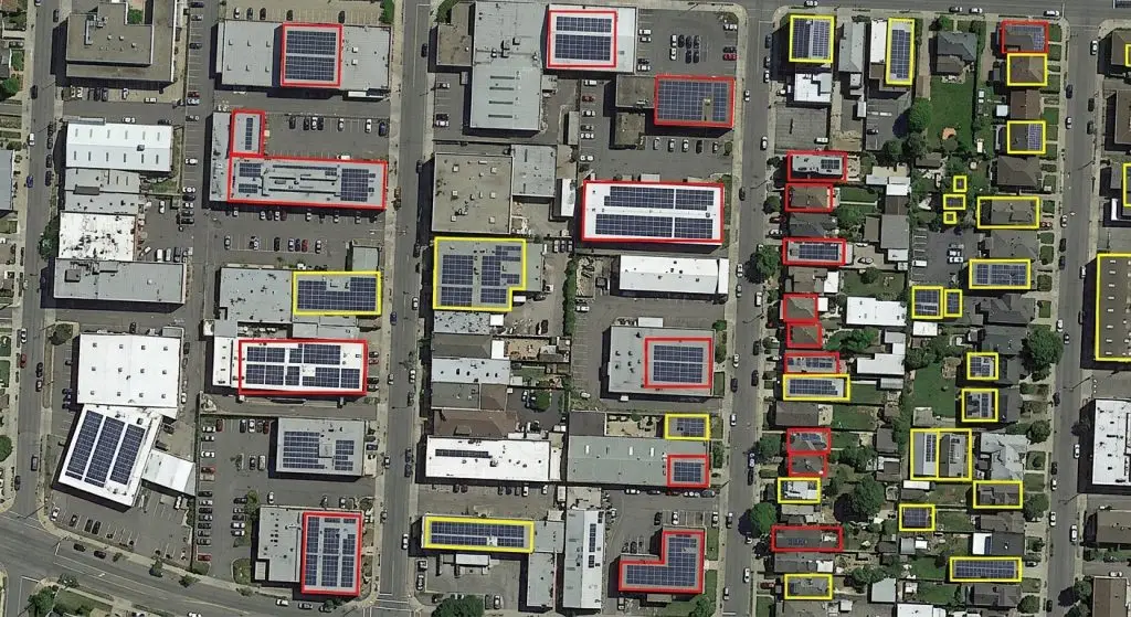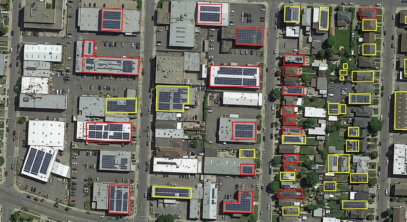
A solar panel occupies a few pixels on ordinary aerial imagery. That smallness governs the whole project, since it makes the object barely visible while giving it a geometric and colorimetric signature few other installations share.
This article sets out those conditions. It extends the article on building detection.
The uses that structure the field
Five solar applications occur in satellite imagery.
Inventorying the stock actually installed across a given territory.
Monitoring the deployment rate observed between two dates.
Estimating the capacity actually connected to the grid.
Spotting the installations that have never been declared.
And commercial prospecting by identifying the roofs already equipped.
One important practical consequence follows. The third use requires a surface estimate rather than a count, which demands precise delimitation where the others would be satisfied with one point per installation.
What the visual signature brings
Five characteristics ease detection in satellite imagery.
A dark and very homogeneous tone, bluish or frankly black.
A rectangular form with systematically right angles.
A regular arrangement in perfectly aligned rows.
A reflectance markedly different from that of roofing materials.
And a consistent orientation across a whole installation.
One important observation follows for a satellite imagery project. Those five characteristics rarely combine elsewhere, which makes this object easier to distinguish than a building despite its far smaller size.
What produces confusions
Five elements resemble a panel seen from above.
A glazed roof or else a rooflight set into the roof.
A solar thermal collector, of extremely similar appearance.
A dark roof, whether in slate or in bitumen.
A rectangular cast shadow falling on a light surface.
And a pool or a pool cover of a dark tone.
One practical consequence follows. The second element is the hardest to rule out, a thermal collector sharing the form, the tone and the siting of a photovoltaic panel, which makes the distinction dependent on details ordinary resolution does not always show.
What resolution determines here
Four thresholds mark the successive capabilities in satellite imagery.
Below a first threshold, an installation stays entirely undetectable.
Beyond that threshold, an installation is spotted without its limits being clear.
Higher still, the installation’s total surface becomes measurable.
And at very high resolution, the individual modules are counted one by one.
One important observation follows. The last threshold is rarely needed, a module count bringing nothing a surface does not already give, which permits saving an expensive resolution on most projects.
What a ground installation changes
Four differences separate a solar farm from an equipped roof in satellite imagery.
The surface concerned exceeds that of a roof by orders of magnitude.
The rows stand out very clearly against a light ground.
The spacing between two rows does or does not belong to the installation.
And the site’s limits read far better than those of an isolated panel.
One important practical consequence follows for a satellite imagery project. The third difference requires an explicit convention, a farm’s surface being able to designate the site footprint or the sum of the rows, a considerable gap that changes every capacity estimate.
What the annotation must produce
Four forms occur according to the intended use.
A simple point per installation, sufficient for a count.
A box enclosing all the panels placed on one roof.
A polygon faithfully following the modules’ real footprint.
And a mask separating the panels from the intervening spaces.
One observation follows. The second form suits partly equipped roofs badly, a bounding box including the uncovered part of the roof, which overestimates the surface as soon as the panels do not form a compact block.
What the reference requires here
Four sources establish a ground truth in satellite imagery.
The connection registers held by the grid operator.
The administrative declarations filed ahead of the works.
Field surveys conducted on a restricted sample.
And very high resolution imagery acquired over the same areas.
One important practical consequence follows. The first source is the most complete and the most lagged, a connection occurring after the physical installation, which produces panels that are visible and not yet registered and that it would be wrong to count as errors.
What the surface permits estimating
Four quantities are deduced from a footprint measured on satellite imagery.
The installed capacity, by applying an average yield per square metre.
The expected annual output, corrected by the local sunshine.
A territory’s equipment rate, set against all of its built surface.
And the potential left to exploit on the roofs still free.
One important practical consequence follows. The first quantity rests on an average yield that evolves with equipment generations, which makes a capacity estimate dependent on an assumption external to the image and requires documenting it with the result.
What the measurement must reflect
Five indicators describe such a satellite imagery system’s performance.
The proportion of installations detected, systematically broken down by size.
The false detection rate, systematically set against the known confusions.
The accuracy of the surface estimated on previously verified installations.
The performance obtained on roofs that are only partly equipped.
And the behaviour observed on regions absent from the training.
One important observation follows for a satellite imagery project. The second indicator deserves breaking down by cause, an overall false detection rate not saying whether the system confuses thermal collectors, rooflights or shadows, information the correction to be made depends on entirely.
What the roof imposes as a constraint
Five characteristics of the support modify the panels’ appearance in satellite imagery.
The roof pitch, which modifies the apparent angle of the modules.
The roof slope’s orientation, which modifies the reflection by the hour.
The colour of the surrounding material, more or less strongly contrasted.
The presence of obstacles, whether chimneys or roof windows.
And the shadow cast by a neighbouring building or tree.
One important observation follows for a satellite imagery project. The second characteristic produces a spectacular effect at certain hours, a specular reflection turning a dark panel into a very light surface, which entirely inverts the expected signature and causes installations that are plainly visible to be missed.
What deployment monitoring requires
Four conditions make a comparison between dates usable in satellite imagery.
A strictly comparable resolution between the two acquisitions.
Neighbouring lighting conditions, the reflection varying strongly by the hour.
A surface convention rigorously unchanged between the campaigns.
And explicit treatment of installations left partly masked.
One important practical consequence follows for a satellite imagery project. The second condition weighs more here than on most objects, an installation detected in late morning being able to disappear from a midday acquisition, which produces false equipment removals across a territory where nothing has moved.
What the imbalance of examples imposes
Four satellite imagery effects accompany an object that is rare across the territory.
A tile taken entirely at random generally holds no panel at all.
Annotation time is spent mostly scanning entirely empty roofs.
A control by random sampling encounters only few positive cases.
And an overall performance lets itself be dominated by the true absences alone.
One important observation follows. The second effect directs the whole organisation of the work, an automatic preselection of the tiles liable to hold an installation considerably reducing the cost, which makes prior filtering a more worthwhile line than accelerating the tracing.
What the corpus must cover here
Five axes structure a panel dataset in satellite imagery.
The types of installation covered, from the individual roof to the ground-mounted farm.
The regions handled, whose roofs and equipment densities differ.
The acquisition hours, which command the reflection of the modules.
The confusing objects, thermal collectors and rooflights included.
And the partly equipped roofs, more delicate than fully covered ones.
One important practical consequence follows. The fourth axis deserves a deliberate effort, a corpus holding only panels and ordinary roofs not letting the system learn to rule out what resembles them, which produces a false detection rate adding positive examples will never improve.
What this work’s throughput presupposes
Four factors determine the time spent per tile in satellite imagery.
The equipment density of the territory actually covered.
The geometry adopted, from the point to the detailed footprint.
The frequency of the confusing objects that must be ruled out.
And the presence of roofs that are only partly equipped.
One important observation follows for a satellite imagery project. The first factor produces a considerable gap between territories, a heavily equipped municipality demanding several times the time of a rural area of the same surface, which makes a per-tile rate inapplicable without an indication of the expected equipment rate.
What the annotator must know here
Five kinds of knowledge condition correct work on this subject.
Distinguishing a photovoltaic module from a mere thermal collector.
A panel’s appearance according to the hour of day and the reflection angle.
The roofing materials most liable to imitate the tone of the modules.
The rule adopted for handling partly masked installations.
And the exact scope of the equipment actually recorded in the reference.
One important practical consequence follows for a satellite imagery project. The second kind is acquired by example rather than by description, an annotator who has seen a few specular reflections recognising them immediately afterwards, which makes a few well-chosen images a particularly effective training investment.
What the delivery format requires here
Four choices condition the client’s reuse of the result.
The geometry finally delivered, point, box or vector footprint.
The attributes attached, such as estimated surface and installation type.
The linkage to a building or else a parcel identifier.
And a statement of the yield assumption used for capacity.
One important observation follows for a satellite imagery project. The last choice avoids a lasting misunderstanding, a capacity delivered without its conversion assumption being taken up as it stands by the client, which turns an estimate carrying reservations into a figure presented as measured.
What pre-annotation permits here
Three uses appreciably lighten the work on this subject.
An automatic filtering of tiles plainly holding no installation.
A footprint proposal bearing on the fully equipped roofs.
And a flagging of the dark surfaces that deserve verification.
Two caveats accompany it in satellite imagery.
Filtering that is too severe discards the most difficult installations.
And a proposal accepted without examination carries forward the confusion with thermal collectors.
What the first batch must establish
Four results justify a trial batch before production.
An average time per tile, measured on territories of quite different densities.
The list of confusing objects actually encountered across the area.
The gap observed between the count produced and a connection register.
And the proportion of installations whose outline remains uncertain.
One important practical consequence follows for a satellite imagery project. The second result directs the whole rest of the project, confusing objects varying strongly with regions and building practices, which makes a list established on the real area more useful than a generic list taken from another territory.
What the image source changes here
Four supports occur for this kind of project.
Aerial orthophotography, at once the finest and the least frequent.
Commercial satellite imagery, more regular but appreciably more expensive.
Public programmes, free but very often insufficient here.
And drone acquisitions, very fine but over limited extents.
One important observation follows. The third support reaches its limit on this precise subject, an installation of a few square metres staying below the detection threshold of free programmes, which makes this one of the rare fields where paid acquisition becomes a condition and not a comfort.
What this subject has in its favour
Four traits make it a good first engagement in satellite imagery.
A purely binary decision, the object is present or it is not.
A control achievable by eye on a restricted sample.
A direct reconciliation possible with an existing administrative register.
And a reference holding a few classes only.
One important observation follows. Those four traits make this subject verifiable by the client themselves, a municipality being able to confront the result with its own declarations without technical competence, which builds a confidence more complex projects take far longer to establish.
What the provider brings here
Four contributions distinguish a solar engagement conducted on satellite imagery.
A reference settling the fate of confusing objects before production starts.
A preselection of tiles, which strongly reduces the volume billed.
A deliberate annotation of the most difficult negative cases.
And a false detection rate broken down by cause rather than presented overall.
One important practical consequence follows. The second contribution reduces the provider’s own invoice while improving the result, a filtered archive concentrating the work where it counts, which makes this proposal more convincing than a discount on the unit price.
Approaching a panel detection project
Five questions scope such a satellite imagery project.
Is counting or estimating a surface required. The geometry differs.
Does the resolution permit delimiting. Otherwise a point suffices.
Do thermal collectors fall within scope. The distinction is difficult.
Is a farm measured by site or by rows. The gap is considerable.
And is the connection reference lagged. It always is.
Those five answers determine the project’s feasibility. Asking them before production avoids an inventory nobody will be able to reconcile with an existing register.
The question that frames the project
One question determines the geometry needed in satellite imagery.
Does the result serve to locate or to quantify.
A location, commercial prospecting or spotting undeclared installations, is satisfied by one point per equipped roof, which permits a high throughput and a modest resolution.
A quantification, a capacity estimate or monitoring of a deployment target, requires a measured surface, an explicit convention and a resolution permitting the modules to be delimited.
That question belongs to the use and not to technique, it is asked before acquisition, and it separates two projects whose cost per installation differs by an order of magnitude.
Three decisions before producing
Three decisions commit a panel detection project in satellite imagery.
Settling whether thermal collectors fall within scope, the distinction staying difficult.
Choosing between a count and a surface estimate, the geometry and the cost depending on it.
And fixing the surface convention for ground-mounted farms, site footprint or sum of rows.
Those three decisions cost one meeting, they precede the first tile, and their absence produces an inventory nobody will be able to reconcile with an existing register.
Three checks on a panel corpus
Three checks qualify an installation dataset in satellite imagery.
The actual presence of confusing objects annotated as such in the corpus.
The written rule bearing on the scope of thermal collectors.
And coverage of several acquisition hours, the reflection varying strongly.
Those three checks are each asked in one question, they require no competence in energy, and their absence indicates a corpus whose false detection rate will stay high whatever volume is added.
What this chapter teaches
One cross-cutting observation deserves closing this examination.
A small but regular object is detected better than a large but variable one.
Three findings compose it.
The combination of tone, form and arrangement makes this object distinctive despite its size.
Confusions come from objects sharing that signature rather than from smallness.
And a farm’s surface designates the site footprint or the sum of the rows depending on the convention.
That finding extends the preceding chapter, an object’s regularity counting more than its dimensions.
What this chapter leaves to the next
A manufactured object is recognised by its regularity, a natural environment never is.
Three questions stay open in satellite imagery.
How to delimit a vegetation formation whose outlines are diffuse.
What a loss of canopy presupposes as a threshold convention.
And how to separate a temporary felling from a lasting conversion.
Those three questions belong to deforestation monitoring, which constitutes the subject of the following chapter.
Why this makes a good entry engagement
One observation about winning geospatial work belongs at the close.
Solar inventory is the easiest of these subjects for a client to audit.
Three reasons follow in satellite imagery.
The decision is binary, so a wrong answer is obvious rather than arguable.
The client usually holds a register they can check the result against.
And a hundred verified roofs settle the question in an afternoon.
One important practical consequence follows for a satellite imagery provider. This makes it worth proposing even where a larger project is the real target, since a client who has audited one deliverable themselves stops asking how quality is assured and starts asking what else can be counted, which is a considerably shorter conversation.
Common mistakes
These failures recur often enough that naming them is usually enough to avoid them.
- Confusing photovoltaic panels with thermal collectors.
- Using a bounding box on a partly equipped roof.
- Comparing an inventory with a connection register without allowing for the lag.
- Leaving implicit the surface convention on ground-mounted farms.
- Aiming at a resolution permitting module counting with no need for it.
- Measuring a false detection rate without breaking it down by cause.
- Neglecting rectangular cast shadows as a source of confusion.
- Evaluating on a single region and a single type of installation.
- Ignoring dark roofs that imitate the tone of the panels.
- Estimating capacity from a count rather than from a surface.
What to take away
Panel detection rests on a signature rather than on a size.
Three readings emerge. The combination of a homogeneous dark tone, a rectangular form and a regular arrangement is rarely met elsewhere, which makes this object easier to distinguish than a building despite far smaller dimensions. Confusions come from objects sharing that signature, thermal collectors and rooflights foremost, rather than from smallness itself, which directs the correction towards the reference rather than towards the resolution. And a ground-mounted farm’s surface designates the site footprint or the sum of the rows depending on the convention adopted, a considerable gap that changes every capacity estimate.
For monitoring natural environments, the article on deforestation details the approach. For networks, the article on infrastructure mapping sets it out.
To explore delivery arrangements, supported formats and applicable control mechanisms, see our dedicated page on annotation for geospatial. And if you are preparing an inventory of solar installations, let us discuss your need.