Forestry and agriculture pose 3D annotation a problem neither the road nor the warehouse poses. The objects to describe have no defined shape, they partly overlap, and the boundary between two neighbouring individuals often exists nowhere in the data.
This article sets out what this context demands. It extends the article on quality in 3D annotation.
What distinguishes this context
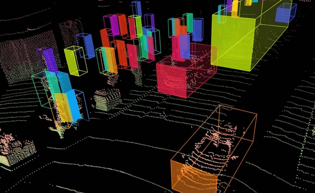
Five properties characterise this 3D annotation vertical. The objects are porous, a tree letting part of the signal through its foliage. The shape is irregular, no geometric primitive correctly describing a crown. Overlap is the rule, neighbouring crowns interpenetrating with no sharp boundary. Seasonal variation is strong, one stand producing two very different clouds depending on the period. And the ground is irregular, which invalidates the horizontal plane assumption common elsewhere. One important practical consequence follows. Those five properties rule out the cuboid as the principal representation, a tree’s footprint saying almost nothing about what this vertical measures.The tasks requested
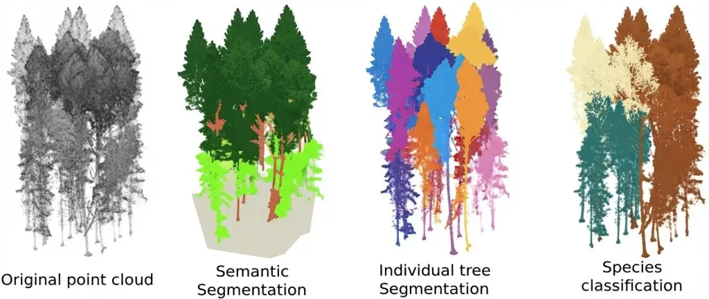
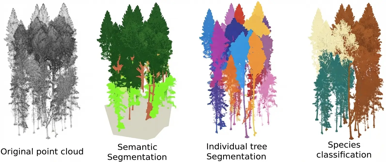
Five 3D annotation formulations occur in this vertical. Their cost differs strongly in 3D annotation. Stem counting, which locates without describing. Separating ground from vegetation, a precondition for almost everything else. Individual segmentation, which separates neighbouring trees or plants. Organ segmentation, trunk, branches and foliage handled separately. And volume or biomass measurement, which presupposes a complete surface description. One observation follows. The second formulation is the most frequent and the most worthwhile, it conditions all the others and it largely automates, which makes it the first line to address in a forestry 3D annotation project.Separating the ground
This operation precedes almost all the others. It is harder than in an urban setting. Three difficulties characterise this operation. Relief, sloping ground not separating by a simple height threshold. Low vegetation, whose limit with the ground belongs to a convention rather than to a discontinuity. And the low density of ground returns beneath a dense canopy, which makes the surface uncertain in places. One practical consequence follows for a 3D annotation project. The third difficulty is the heaviest, a tree height being measured against an interpolated rather than an observed ground, which carries the ground’s uncertainty into every derived measurement.Separating individuals
This difficulty dominates the vertical and it is structural. Two neighbouring trees present no measurable boundary where their crowns meet. Four conventions coexist in 3D annotation. Separation by trunk, which assigns each point to the nearest trunk. Separation by branch continuity, more correct and more expensive. Separation by distance to the apex, a fast and coarse approximation. And declining to separate, the clump constituting a single unit for all purposes. One important observation follows. Those four conventions produce non-combinable corpora, and the choice belongs to the downstream use, a stem inventory and a global biomass measurement not calling for the same decision.What the canopy changes
This property of the environment determines what is observable. The signal partly traverses the foliage and attenuates with depth. Four consequences follow in 3D annotation. Point density falls with depth into the canopy. The understorey is badly sampled, which makes its annotation uncertain. Trunks are partly occluded by low branches. And the season changes everything, a winter survey on broadleaves penetrating far better than a summer one. One important practical consequence follows for a 3D annotation project. The last consequence requires declaring the acquisition period as metadata, two surveys of the same stand in two seasons not carrying the same information.Crops and their particularities
Four differences separate the agricultural from the forestry context in 3D annotation. Regularity, a row crop presenting an organisation forest does not have. Object size, a plant being described at a scale far below that of a tree. The speed of change, a canopy changing in weeks rather than in years. And density, a row of cereals not decomposing into separable individuals. One observation follows for a 3D annotation project. The first difference is exploitable, the regularity of rows supplying a control constraint forest does not, a plant out of alignment signalling either an error or a real anomaly.What the measurement expects
Four quantities constitute the real deliverable of most 3D annotation projects here. Height, measured from ground to apex and dependent on the quality of the interpolated ground. Trunk diameter, whose measurement presupposes sufficient density at breast height. Crown volume, which depends entirely on the separation convention adopted. And stem density per unit area, which depends on the counting convention. One practical consequence follows. Those four quantities depend more on the annotation conventions than on the sensor’s precision, which makes documenting them indispensable to any comparison between surveys.Organ segmentation
A demanding formulation deserves separate treatment since it serves precise uses. Distinguishing trunk, main branches and foliage presupposes criteria geometry alone does not always supply. Four difficulties characterise this formulation. The transition from trunk to first branch, which belongs to a diameter or angle threshold rather than to a discontinuity. Fine branches, badly sampled and often indistinguishable from foliage. Ivy and epiphytes, which belong to the tree without being organs of it. And dead wood retained in the crown, whose attribution depends on the use. One practical consequence follows for a 3D annotation project. Those four difficulties justify restricting this formulation to the uses that genuinely require it, timber volume estimation or architectural study, rather than adopting it out of a concern for completeness.What quality control exploits
Five 3D annotation verifications suit this vertical. Height plausibility, a given species having a known range. Consistency between diameter and height, two quantities linked by an allometric relation. Stem density per unit area, an aberrant value signalling a separation problem. Alignment in an agricultural context, a plant out of row calling for verification. And continuity of the interpolated ground, an abrupt discontinuity signalling a classification error. One important observation follows for a 3D annotation project. The second check is specific to this field and very effective, the relation between diameter and height being sufficiently constrained biologically that a large divergence betrays a measurement or attribution error.The carriers and what they permit
Four acquisition configurations occur in this vertical and they do not give access to the same quantities. The static terrestrial survey, which describes trunks and understorey finely and covers a small area. The mobile terrestrial survey, which covers more and loses precision on detail. The under-canopy drone, which combines coverage and detail at the price of demanding logistics. And the aerial survey, which covers vast areas and describes apexes well and trunks badly. One important observation follows for a 3D annotation project. The fourth carrier produces the most frequent and most constrained configuration, a stem inventory from an aerial survey resting on apex detection rather than on trunk observation, which changes the nature of the result.Monitoring over time
A requirement specific to this vertical appears as soon as a second campaign is planned. Comparing two surveys of the same site presupposes more than the same method. Five conditions must be met in 3D annotation. Identical separation conventions, failing which an apparent change reflects a change of rule. A comparable season, the penetration gap between two periods often exceeding the growth measured. Geometric registration between the two clouds, without which the individuals do not correspond. An established individual correspondence, each stem in the second survey being attached to a stem in the first. And a record of individuals lost and gained, information often more useful to the operator than mean growth. One important observation follows for a 3D annotation project. The fourth condition is the most expensive and the most omitted, monitoring with no individual correspondence measuring only a global change where the use expected a change per stem.What this work costs
Four factors determine the 3D annotation load in this vertical. The overlap rate between crowns, the dominant factor determining separation difficulty. Stem density, which multiplies the number of objects to separate. The formulation adopted, from counting to organ segmentation. And the presence of an understorey, which adds a badly sampled layer to handle separately. One practical consequence follows. The first factor produces a considerable variation, an open stand and a closed one not comparing even at equal stem counts in 3D annotation.What pre-annotation contributes here
Three observations situate the contribution of 3D annotation assistance in this context. Ground and vegetation separation automates well and constitutes the most immediate gain. Trunk detection works correctly in an open stand and degrades sharply under a dense canopy. And individual separation stays the weak point, automatic proposals reproducing the ambiguities rather than resolving them. One practical consequence follows for a 3D annotation project. Those three findings lead to a clear division, assistance handles the ground and locates the trunks, the human arbitrates the separations and the overlap cases.What this vertical does not permit
Four limits bound what a 3D annotation can establish here. The understorey under a dense canopy stays badly described, the data being missing rather than the effort. Separating individuals in a closed canopy rests on a convention rather than on an observation. Biomass is not measured directly, it is inferred from a model applied to the annotated quantities. And comparing two surveys presupposes identical conventions and seasons. That second limit deserves emphasis. It means a stem inventory in a closed stand produces a result dependent on the convention, which must be declared rather than presented as a measurement.The first batch of a forestry project
Four plots compose a pilot batch that genuinely tests the conventions. A plot in an open stand, which supplies the reference throughput and verifies basic feasibility. A plot in a closed canopy, which measures the principal cost factor and tests the separation convention. A plot on a slope, which tests ground separation in the least favourable conditions. And a plot with a dense understorey, which verifies that the feasibility caveat is correctly framed. One observation follows. The throughput gap between the first two plots is this batch’s most useful figure, it directly measures the effect of overlap and it supplies the basis for a costing the stem count does not permit in 3D annotation.The conventions to write first
Five rules cover most of the disagreement in this vertical. The individual separation convention, chosen from the four set out and declared explicitly. The threshold separating low vegetation from the ground, expressed as a height above the interpolated ground. The counting criterion for multiple stems from one stool. The treatment of dead wood and fallen stems. And the minimum diameter below which a stem is not inventoried at all. One practical consequence follows for a 3D annotation project. The third rule produces the most frequent disagreement in broadleaved stands, a coppice stool counting as one stem or as many stems as it carries shoots according to the forestry convention adopted.The uses that govern
Five purposes occur in this vertical and they do not call for the same formulation. Forest inventory, which needs stems counted and measured and is satisfied by a localisation. Biomass estimation, which needs volumes and presupposes a surface description. Growth monitoring, which needs an individual correspondence between two dates. Dieback detection, which needs a crown condition rather than a fine geometry. And crop phenotyping, which needs separated organs at the scale of a single plant. One observation follows for a 3D annotation provider. Those five purposes are distinguished by a simple question, what is counted or what is measured, and that distinction steers the choice of formulation more reliably than a discussion of method.What field validation brings
A practice specific to this vertical deserves setting out since it does not exist elsewhere. A conventional field survey supplies a reference independent of the cloud. Three contributions follow for a 3D annotation project. Verification of diameters, measured by tape and compared with those inferred from the cloud. Checking the count, a manually inventoried plot bounding the omission rate. And validating the convention, a disagreement between field inventory and annotation revealing a rule misaligned with forestry practice. One important practical consequence follows for a 3D annotation project. The third contribution is the most useful and the least sought, a systematic gap frequently revealing that the annotation convention does not match the one the operator has always used.Approaching a forestry or agricultural project
Five questions scope a forestry or agricultural 3D annotation project. Which quantity constitutes the real deliverable. That answer determines the formulation. Which individual separation convention. That answer conditions comparability. Which season and which phenology. That answer bounds what is observable. Is the understorey part of the scope. A positive answer calls for a caveat on feasibility. And is comparison with an earlier survey expected. That answer requires adopting its conventions. Those five answers determine the load and the feasibility. Asking them before starting avoids an inventory whose figures compare to nothing.The question that frames the project
One question determines the formulation and it concerns the deliverable. Will the result be a number per unit area or a value per individual. A per-area answer, stem density or biomass per hectare, tolerates an approximate separation in a closed canopy and places the project in the most economical regime. A per-individual answer, inventory or growth monitoring, requires a strict separation convention and a correspondence between campaigns. That question is asked in one sentence, it belongs to the use and not to the technique, and it avoids imposing a costly individualisation on a project an aggregate would have served.Three decisions before the first plot
Three decisions commit the comparability of a forestry 3D annotation corpus. Choosing and declaring the individual separation convention, which determines the result more than the sensor used. Fixing the minimum inventoried diameter, which bounds the work volume without reducing usefulness. And settling the acquisition period according to phenology, since a survey out of season compares to no other. Those three decisions cost one meeting with a forester, they precede the first outing, and their absence produces an inventory whose figures compare neither with one another nor with the operator’s own.What this vertical brings to the others
Three practices born here hold beyond forestry and agriculture. Control by a relation between quantities, applicable anywhere two measurements are linked by a known law. Validation by a reference external to the cloud, transferable as soon as an independent survey exists. And declaring the convention as a component of the result, necessary whenever a boundary does not exist in the data. Those three practices answer one same situation, that where the data alone does not determine the result, a configuration far more widespread than this vertical suggests. Recognising it early is what separates a corpus that can be defended from one that merely looks careful.What this chapter teaches
One cross-cutting observation deserves closing this examination. This vertical measures quantities whose value depends on a convention rather than on a sensor. Three findings compose it. Individual separation has no foundation in the data under a closed canopy, which makes the convention the source of the result. Height depends on an interpolated ground under a dense canopy, which carries an invisible uncertainty into a quantity presented as measured. And biological relations between quantities supply checks neither the road nor the warehouse supplies. That finding matches the one the weed detection cluster established: where the target is living, ground truth belongs to expert judgement as much as to observation, and a corpus’s quality lies in the stability of that judgement.Why the domain expert must be in the room
One observation about how these projects run belongs here, since it separates them from the other verticals. The conventions in this field already exist outside the annotation project. Three consequences follow for a 3D annotation project. Forestry practice has settled the coppice question, the minimum diameter and the plot definition long before anyone brought a scanner, so inventing new rules produces figures the operator cannot use. The quantities delivered feed decisions with financial or regulatory weight, which makes an undeclared convention a liability rather than a detail. And the operator can usually say which convention they need in one sentence, provided someone asks. One practical consequence follows for a 3D annotation provider. The scoping meeting for this vertical should include whoever will use the figures, not only whoever commissions the corpus, since the two are frequently different people and only the first knows which conventions the result must respect.Common mistakes
These failures recur often enough that naming them is usually enough to avoid them.- Using a cuboid to describe a tree.
- Not declaring the individual separation convention.
- Comparing two surveys carried out in different seasons.
- Separating the ground by a simple height threshold on sloping terrain.
- Presenting a height under a dense canopy as a direct measurement.
- Including the understorey with no caveat on its feasibility.
- Neglecting the diameter-height consistency check.
- Omitting the acquisition period from the metadata.
- Expecting an automatic separation to settle a closed canopy.
- Costing by stem count without accounting for overlap.