
Vegetation management under power lines is the aerial LiDAR use where geometric precision matters most. It is not about describing a landscape but about measuring a distance between two objects, and that distance conditions a network’s safety.
This article sets out what this use requires, what distinguishes it from the others and the annotation demands that follow. It extends the article on forestry.
The problem to solve
A physical constraint founds this aerial LiDAR use. It explains its level of requirement. An electrical conductor must keep a minimum distance from any vegetation, failing which contact or flashover causes an outage, a fire or an accident. Three difficulties make that surveillance particularly complex. Networks are very extensive, an operator potentially running tens of thousands of kilometres of line. Vegetation grows continuously, which makes a one-off inspection rapidly obsolete. And a conductor’s position varies, the catenary moving under the effect of temperature, electrical load and wind. That third difficulty radically distinguishes this use from the others. The distance measured on a given day is not the distance under the most unfavourable conditions, which the following section develops.The question of conductor position
This subtlety dominates any aerial LiDAR project on a network and omitting it produces wrong analyses. An overhead cable describes a curve whose sag depends on its temperature, itself a function of ambient temperature and of the current passing through it. Three important consequences follow. The position measured during the survey corresponds to that day’s conditions, generally favourable since flights take place in calm weather. The most unfavourable position, under high heat and high load, places the conductor several metres lower. And lateral displacement under wind brings the conductor closer to side vegetation. One important methodological consequence follows. The analysis concerns not the measured position but a position modelled under unfavourable conditions, a computation requiring the cable’s mechanical characteristics and turning a measurement into a simulation. That distinction has commercial reach. A provider delivering measured distances delivers incomplete information, and the value sits in computing the most constraining theoretical position.What the survey must contain
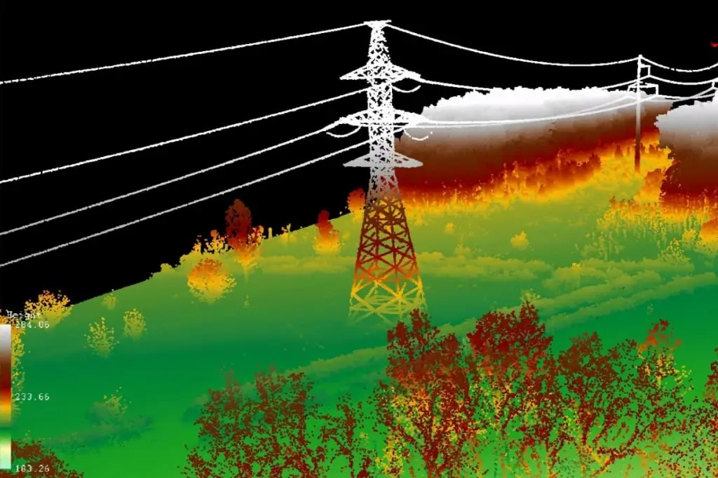
Four categories of object must be identified in aerial LiDAR. Their annotation constitutes the central work. The conductors, current-carrying cables, each phase of which must be distinguished. The earth wires, sitting above the conductors and intended for lightning protection. The supports, pylons and poles, whose position defines the spans. And the vegetation, distinguished by stratum and located relative to the corridor. Two complementary categories are also requested. Nearby buildings and structures, subject to distinct regulatory distances. And the ground, needed both for computing vegetation height and for ground clearance checks. One important observation follows. This annotation is markedly finer than that of a forestry survey, each cable having to be individualised rather than classed in a generic category.Why aerial LiDAR is indispensable here
One property settles this definitively in favour of this technology. An electrical conductor is an object whose cross-section is far below the resolution of any aerial imagery. Photogrammetry fails to reconstruct it, a cable not occupying enough pixels to produce a correlatable pattern, which the comparison article detailed. Aerial LiDAR measures it nonetheless, a pulse meeting the cable producing an echo at the correct distance whatever fraction of the footprint it occupies. Three consequences follow. This use imposes this technology with no alternative. Point density must suffice for several pulses to meet each cable. And helicopter acquisition is frequent, its reduced speed and low altitude producing the density needed over a narrow corridor.The specific annotation difficulties
Five configurations complicate this work. They have no equivalent in the other uses of aerial LiDAR. Separating the phases, several parallel and close conductors having to be distinguished individually, which requires sufficient density and examination in section. Sparse points on cable, a pulse on a thin cable sometimes producing a weak echo that noise filtering wrongly discards. Crossings and spans over other lines, where several lines superimpose and attributing a point to a line becomes ambiguous. Line equipment, insulators, markers and splices, whose classification belongs to a convention. And overhanging vegetation, whose points mingle with the conductor’s when a branch approaches it, which is precisely the situation to be detected. That last configuration is this use’s paradox. The cases hardest to annotate are exactly those presenting the highest risk, which forbids treating them as marginal.The corridor and its extent
This notion belongs to a convention rather than to an observation. It structures any aerial LiDAR project on a network. The corridor denotes the strip of land along the line where vegetation is monitored and managed. Three definitions coexist and confusing them produces frequent misunderstandings. The legal easement corresponds to the servitude established by agreement with landowners, a fixed width independent of configuration. The management zone corresponds to the strip actually maintained, which may be narrower or wider according to practice. And the risk zone corresponds to all vegetation capable of reaching the line, notably by falling, which extends it well beyond the other two where large trees are present. One practical consequence follows for a project. The width of strip to annotate depends on the definition adopted, and a survey limited to the legal easement does not permit fall-tree analysis, which must be settled at scoping rather than discovered at delivery.The precision required
This requirement exceeds that of the other aerial LiDAR uses. It has cascading consequences. A pruning decision rests on a distance of a few metres, which makes a decimetre error significant where it would be negligible in forestry. Three consequences follow. Point density must be high, several tens per square metre being common on this type of survey. Georeferencing must be verified, a systematic offset displacing every computed distance. And the classification must be exact rather than globally correct, a vegetation point classed as conductor or the reverse producing a false alert or an omission. One economic consequence follows. Cost per kilometre far exceeds that of a forestry survey per unit area, and it is justified by the value of an avoided outage.The aerial LiDAR analyses produced
Four deliverables derive from this aerial LiDAR annotation. They serve distinct decisions. Distance infringements list the points where vegetation sits below the regulatory threshold, classified by severity. Growth forecasts estimate when currently compliant vegetation will cross the threshold, permitting planning rather than reaction. Fall-tree analysis lists the specimens that, if they fell, would reach the line, a distinct analysis since it concerns currently distant trees. And intervention priorities combine these elements with accessibility and line criticality. One observation runs across those four deliverables. The second and third create most of the value, detecting a current infringement being a statement of fact where anticipation permits organising a pruning campaign.Automation and its limits
A substantial part of this work lends itself to automation and it is worth bounding the scope. Three operations automate quite correctly. Conductor detection, a taut cable’s geometry being highly characteristic, a regular curve aligned between two supports, which makes it recognisable by geometric methods. Distance computation, once the objects are classified, a purely geometric and entirely automatable operation. And severity classification, applying regulatory thresholds to computed distances. Three operations resist in return. Phase separation in dense configurations, where several close conductors require examination. Handling crossings and spans, where attribution depends on understanding the configuration. And the vegetation to conductor interface, precisely where the issue sits, the points mingling as a branch approaches a cable. One practical consequence follows for an aerial LiDAR project. The automatic chain handles most of the linear extent and leaves a percentage of configurations concentrating the risk, which makes targeting the human verification decisive and makes the ability to identify those zones a competence in itself.The other linear networks
Four families share this logic and they widen the market for this competence. Railways require clearance checking, vegetation and obstacles having to respect a free volume around the track, plus surveillance of catenaries whose geometry resembles that of power lines. Overhead pipelines and industrial structures require deformation and proximity monitoring. Roads require clearance checking under structures and roadside vegetation surveillance, with visibility issues alongside contact ones. And aerodrome approach corridors require verification of obstacle limitation surfaces, obstacles and vegetation together. One observation runs across those four families. All rest on the same operation, measuring a distance between an object of interest and its surroundings, which makes the competence acquired on power lines directly transposable. One commercial consequence follows for an aerial LiDAR provider. An investment in this competence serves several markets rather than one, which appreciably improves its return.What this use requires of a provider
Three requirements distinguish it commercially from the other uses of aerial LiDAR. Recurrence, vegetation growing continuously, which turns a one-off engagement into a monitoring contract and modifies the commercial relationship. Traceability, a pruning decision having legal consequences and an omission being citable in the event of an incident. And reliability, a false alert costing an unnecessary visit and an omission potentially costing an outage, which makes both error types expensive and forbids privileging one over the other. That third requirement deserves emphasis. Many uses tolerate an imbalance between omissions and false detections, this one does not, which calls for quality control measuring both separately.Quality control on this type of project
Four arrangements answer the reliability requirement this use imposes. Systematic verification of detected infringement zones, each alert having to be confirmed before transmission to the operator, a false alert costing a visit. Sampling of zones declared compliant, the only way to measure the omission rate, a failure mode that does not announce itself. Conductor continuity checking, a cable interrupted in the classification producing an unanalysed span nothing signals. And cross-checking against the previous campaign, an infringement disappearing with no recorded intervention or appearing abruptly signalling a classification inconsistency rather than a real change. That fourth arrangement is the most informative on a recurring engagement. It uses the history as a reference and it reveals defects no isolated check shows. One observation completes those four. Measuring omissions and false alerts separately is indispensable here, a global indicator masking precisely the trade-off this use forbids.Monitoring over time
This dimension distinguishes this aerial LiDAR use. It modifies the nature of the engagement. Vegetation grows, which makes a statement of fact perishable and turns a one-off engagement into a recurring arrangement. Four requirements accompany that recurrence. Comparability between campaigns, presupposing identical classification conventions and consistent georeferencing, failing which a measured discrepancy reflects a change of method. Growth measurement, permitting forecasts to be calibrated on locally observed rates rather than on generic values. Intervention tracking, a completed pruning having to appear in the following campaign and its persistence signalling an execution defect. And retention of earlier campaigns, constituting the history permitting a decision to be justified and diligence to be demonstrated. One important commercial consequence follows. That recurrence transforms the client relationship, a multi-year contract replacing an isolated engagement, and it advantages the incumbent provider whose history and conventions are already established.Cost against stake
An economic reading justifies this use’s level of requirement. The cost per kilometre of an aerial LiDAR corridor survey markedly exceeds that of a forestry survey per unit area, through the density required and the low altitude flight. Three elements nonetheless justify it. The cost of an outage, combining contractual penalties, crew mobilisation and reputational damage to an operator. The cost of a fire started by a line, of an entirely different order and engaging liability. And the cost of the pruning itself, pruning targeted on genuinely at-risk zones costing a fraction of systematic pruning of the whole linear extent. That third element deserves emphasis because it is often the first argument. Surveillance is justified not only by incidents avoided but by optimising maintenance, an operator moving from a systematic cycle to prioritised intervention. One consequence for a commercial proposal follows. Costing the pruning saving is more convincing than costing the risk avoided, the first being certain and measurable where the second stays probabilistic.The competence this use builds
One commercial observation deserves stating because it informs an investment choice. This use is demanding and it builds a competence that pays elsewhere. Three gains follow. Thin object detection, transposable to any linear infrastructure as the corresponding section showed. Distance computation between classified objects, a generic operation serving any clearance check. And a discipline of reliability, a use where omissions and false alerts cost equally imposing control practices above the sector average. That third gain is the most transferable. A team used to measuring those two failure modes separately naturally applies that rigour to other projects, which raises the general level rather than staying confined to one use.Approaching a network project
Five questions scope an aerial LiDAR corridor project and they are asked in one meeting. Which corridor definition applies. That answer determines the strip width to handle and conditions whether fall-tree analysis is possible. Are the conductors’ mechanical characteristics available. Their absence precludes unfavourable position modelling and reduces the deliverable to a statement of fact. Is this a state or a recurring arrangement. That answer determines the comparability requirements and the nature of the contract. What point density does the survey carry. Insufficient density prevents reliable cable detection and makes the project infeasible before any discussion of method. And how will the alerts be used. Direct transmission to pruning crews imposes a low false alert rate the detection threshold must reflect. Those five answers determine feasibility, scope, contract and parameters. Asking them before drafting a proposal avoids this domain’s most expensive error, promising a risk analysis from a survey that only permits a statement of fact.What this use case teaches
One cross-cutting observation deserves closing this examination because it contrasts with the forestry case. These two uses of aerial LiDAR exploit the same data and they require opposite things. Forestry measures statistically, a local error compensating at stand scale, and it tolerates a globally correct classification. Network management measures pointwise, each configuration counting individually, and it requires an exact classification object by object. Three consequences follow. The annotation protocol differs entirely, one privileging overall consistency and the other local exactness. Quality control differs equally, sampling sufficing for the first where the second requires exhaustive verification of detected cases. And the cost per unit area differs by an order of magnitude, which follows from that requirement rather than from a difference of technology. A general lesson follows for a provider. The same data serves opposite requirements, and a protocol designed for one use applied to the other produces either a needless overcost or a dangerous shortfall, which makes the question of use prior to any discussion of method.What the operator actually needs
One observation about the aerial LiDAR deliverable deserves setting out, since a technically excellent analysis can still fail to be used. An operator does not act on a point cloud or on a distance table. They dispatch crews, and what reaches those crews determines whether the work happens. Four properties make an analysis actionable. Location precise enough to find the tree, which means a description a crew can navigate to rather than only a coordinate. Access information, a compliant tree on inaccessible terrain and one beside a road not representing the same intervention. Prioritisation that reflects operational reality, grouping nearby interventions rather than ordering strictly by severity, since travel dominates crew time. And a format that enters the operator’s existing systems, an analysis requiring manual re-entry being used partially at best. One consequence follows for a provider. The gap between a correct analysis and a used one is largely a matter of these four properties, and none is technical, which makes them cheap to address and easy to overlook. That gap is worth asking about directly at scoping. What happens to this output, and who reads it, are questions that shape the deliverable more usefully than any discussion of precision.Common mistakes
These failures recur often enough that naming them is usually enough to avoid them.- Analysing measured distances without modelling the conductor’s unfavourable position.
- Neglecting lateral displacement under wind.
- Filtering weak echoes on cable as noise.
- Not individualising a line’s phases.
- Treating overhanging vegetation as a marginal case.
- Using a point density insufficient to detect thin cables.
- Neglecting fall-tree analysis in favour of current infringements alone.
- Delivering a statement of fact with no growth forecast.
- Optimising the omission rate at the expense of false alerts.
- Omitting to verify georeferencing before computing distances.