
Image & Data Annotation
for the smart city
A team of data and computer vision experts for smart cities
Home > Image and Data Annotation for the Smart City
What We Do
A team dedicated to Smart City projects, bringing expertise, rigor, and precision.
Unlock the full potential of your city’s data. Our expert team transforms images and text into precise, reliable annotations, powering smarter traffic, safer streets, and more efficient urban services for the cities of tomorrow
Rigorous and Controlled Process
Definition of objectives and KPIs (safety, traffic, service), annotation guidelines and class schema design, pilot phase, iterative cycles with inter-annotator QA, regular audits, and dashboards (IoU, F1, mAP, class coverage, drift) ensuring transparency, robustness, and continuous improvement.
Security & Compliance (ISO 27001 / GDPR)
Secure pipelines with encryption, access control, logging, environment segregation, anonymization of faces/license plates, and strict data retention policies.
Multi-Sensor Annotation
Covers fixed cameras (intersections, parking lots, transit), urban LiDAR/radar, IoT sensors (counts, weather, pollution), GIS data, and textual sources (ordinances, reports, incidents). Supports 2D/3D, tracking, sensor fusion, temporal analysis, standardized via urban ontologies (VRUs, modes, infrastructure).
EXpertise
Fueling AI to secure public spaces, streamline urban mobility, parking, and preventive maintenance.
At Infoscribe, we combine domain expertise, human precision, and MLOps tools to deliver reliable, consistent, and training-ready datasets.
Trust Infoscribe to transform images, videos, point clouds, IoT streams, and documents into high-quality, secure, and actionable annotated data.
2D & 3D Annotation for Computer Vision
Urban Safety and Incident Prevention
Real-time detection and tracking of crowds, suspicious behaviors, unauthorized zone crossings, or abandoned objects. Video sequence annotation for training intelligent surveillance models capable of automatically alerting in case of anomalies.
Multimodal Mobility Flow Management
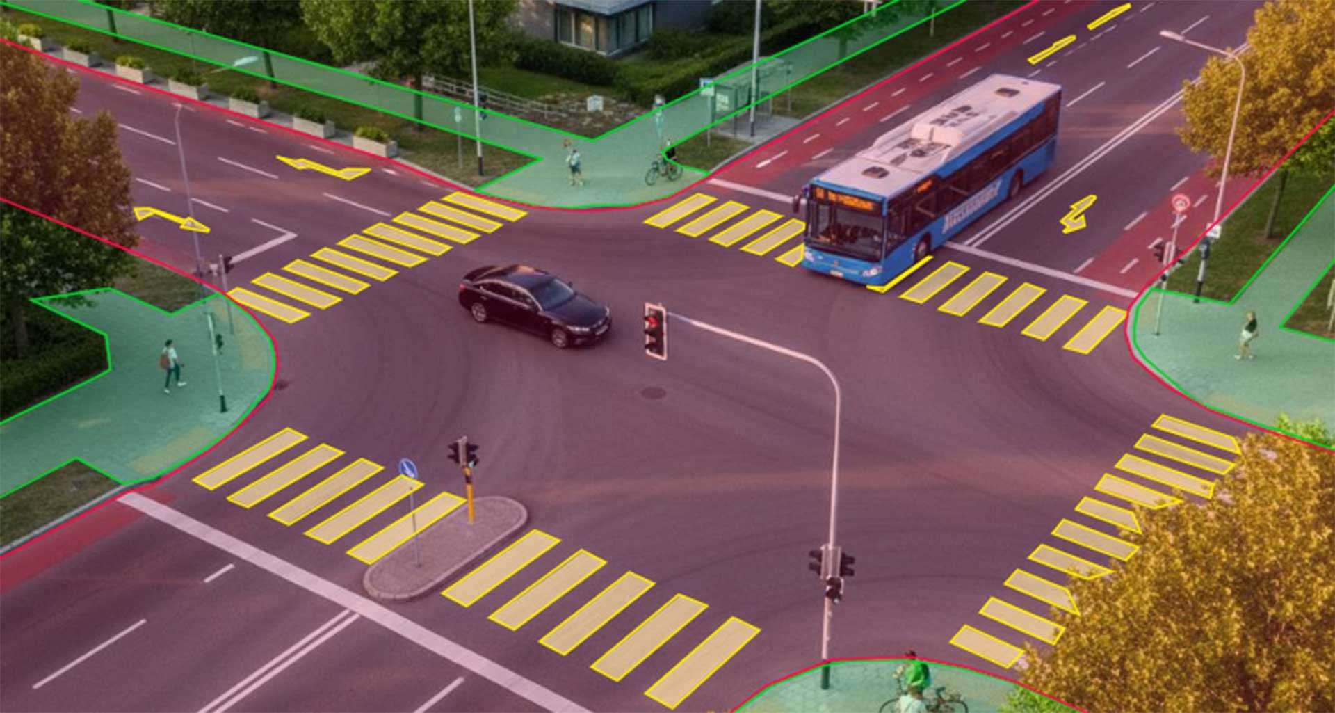
2D/3D annotation of pedestrians, cyclists, e-scooters, cars, and buses. Trajectory extraction, speed tracking, and VRU (vulnerable road user) interaction analysis to model behaviors and anticipate traffic conflicts.
Traffic Regulation and Signal Optimization
Multi-object tracking (MOT/MOT-3D) and panoptic annotation of complex intersections. AI learns to adjust traffic light timing based on vehicle density, direction, and type to optimize flow..
Smart Parking and Curb Management
Annotation of aerial or ground images to detect occupancy, violations, double parking, or delivery zones. Annotated data feeds dynamic pricing and parking optimization models.
Environmental Monitoring and Air Quality
Fusion of camera annotations, IoT sensors, and GIS to correlate urban activities (traffic, construction, events) with pollution or noise levels. Detection of emission sources and generation of dynamic environmental maps
Infrastructure Management and Maintenance
2D and 3D annotation to identify cracks, deformations, corrosion, damaged signage, or intrusive vegetation. AI models classify anomalies and prioritize interventions on roads, bridges, streetlights, and networks.
Chimney Detection in Urban Environments
Analysis of high-resolution aerial imagery to detect and locate chimneys using oriented bounding boxes, aimed at improving urban mapping, building monitoring, and local energy policies.
Public Event Counting and Analysis
Multi-camera video annotation to estimate density, movement, and behaviors in high-attendance areas (protests, concerts, stadiums). Supports planning and congestion prevention.
Automated Public Transport Inspection
3D annotation of buses, trains, or trams to detect defects (cracks, dirt, impacts) and visually verify doors, seats, and onboard sensors.
Road Signage and Pavement Analysis
2D/3D annotation for recognizing signs, traffic lights, road markings, and electrical boxes. Data supports urban map updates and autonomous driving system calibration.
Energy Management and Urban Lighting
Annotation of thermal and infrared images to detect energy losses, faulty lights, and overconsumption in public lighting networks.
Waste Management and Urban Cleanliness
Annotation of images from onboard or fixed cameras to identify illegal dumping, overflows, uncleaned areas, or missing bins. AI models optimize collection routes and urban maintenance.
Maritime and Port Surveillance
2D image and LiDAR point cloud annotation to detect vessels, containers, restricted zones, and unauthorized movements in ports or docking areas
Critical Infrastructure Monitoring
Multi-sensor annotation (camera, radar, LiDAR) for monitoring bridges, tunnels, dams, and power networks. Automated vision detects structural anomalies, intrusions, or degradation.
Urban Planning and Dynamic Mapping
2D/3D annotation of buildings, roads, and public spaces from satellite, aerial, or mobile survey data. Enriched data feeds 3D city models for planning, energy simulation, and climate resilience.
Text Data Annotation for AI
Regulatory and Open Data Indexing
Annotation and structuring of municipal decrees, project reports, calls for tenders, and open data sets. Texts are enriched with metadata, thematic categories (mobility, energy, safety, environment), and key entities for optimized semantic search.
Mobility Monitoring and Citizen Participation
Annotation of messages from participatory platforms, social media, and citizen forms. Extraction of intentions, locations, and topics (parking, cleanliness, traffic, nuisances). AI models classify and prioritize requests to accelerate service response.
Incident Management and Maintenance
Annotation of tickets, technical reports, emails, or SMS from field agents to extract events, equipment, and emergencies. AI detects recurring anomalies and automatically directs interventions.
Operational and Transport Document Analysis
Annotation of traffic bulletins, operation notes, and maintenance reports for networks (bus, tram, metro). NLP models summarize and classify incidents to improve real-time management.
Urban Security and SOC Supervision
Annotation of textual logs (system logs, patrol reports, cybersecurity alerts). Extraction of entities (sites, incidents, threats), detection of correlations between alerts, and automation of alerting or investigation processes.
Urban Planning and Sustainable Development
Annotation of study reports and public contributions to extract projects, zones, and environmental objectives. AI aggregates trends and maps urban priorities (soft mobility, green spaces, energy).
Communication and Citizen Transparency
Annotation of press releases, newsletters, and municipal council reports to enable automatic thematic summaries or multilingual translation of public content.
Public Procurement and Tender Analysis
Annotation of contractual documents to extract criteria, deadlines, amounts, and awardees. AI assists in search, monitoring, and compliance in public procurement processes.
Project Monitoring and Administrative Reporting
Annotation of minutes, schedules, and progress reports. NLP models detect delays, risks, and dependencies, generating automated summaries for managing complex urban projects.
Detection of Weak Signals from Field Feedback
Textual annotation of agent reports, citizen messages, and IoT logs to identify recurring failures, risk areas, or emerging problems before they become critical.
Urban Service and Schedule Optimization
Annotation of complaints, satisfaction surveys, and service feedback (waste, roads, sports/cultural facilities) to identify problematic time slots, adjust service frequency, and align provision with actual citizen usage.
Mapping Social Needs and Urban Vulnerability
Annotation of social reports, field surveys, and community exchanges to extract zones, populations, and sensitive topics (precarity, isolation, access to services). AI helps prioritize actions and target support programs.
Autres Secteurs d'activité
FAQ
Frequently Asked Questions
Infoscribe can annotate a wide range of data specific to smart urban environments. We handle both static images from city cameras, stationary sensors, mobile captures, or drones, as well as continuous video streams—essential for analyzing traffic, detecting unusual behaviors, or monitoring urban developments in real time. Our teams are also skilled in processing 3D point clouds from onboard LiDAR, mobile acquisitions, or photogrammetric surveys, often used for modeling streets, buildings, and urban infrastructure.
In addition, Infoscribe can work with all forms of textual and documentary data related to Smart Cities: incident reports, event descriptions, technical records, intervention notes, human field annotations, or automated messages. This enriches visual data with contextual or operational information.
By combining images, video, and text, we cover key needs: traffic management, urban safety, infrastructure inventory, mobility analysis, environmental monitoring, public space assessment, and behavior analysis. Our methods are adapted to the required granularity (object detection, fine segmentation, classification, textual entity extraction) and can handle very large volumes—essential for large-scale Smart City projects
Infoscribe provides a wide range of annotation techniques tailored to urban challenges. For images and videos, we use bounding boxes, semantic segmentation, instance segmentation, polygons, keypoints for human pose, and multi-frame tracking to follow individuals, vehicles, or objects over time. These methods support use cases such as detecting pedestrians, bicycles, signs, infrastructure, containers, traffic zones, street furniture, and more.
For 3D data, Infoscribe can annotate LiDAR point clouds with volumetric segmentation, object labeling, category classification (buildings, trees, sidewalks, vehicles), or infrastructure extraction. We are proficient with common formats and can deliver outputs compatible with client pipelines.
For textual data, we offer entity extraction (NER), document classification, incident annotation, event categorization, and report structuring. By combining visual and textual annotations, our solution supports multimodal analysis—crucial in Smart Cities to simultaneously understand both the environment and its operational context.
Smart City applications involve critical use cases: safety, mobility, surveillance, risk management, and urban optimization. Infoscribe therefore implements a strict, multi-layered quality process. First, we develop highly detailed guidelines with the client, defining object classes, interpretation rules, visual boundaries (occlusions, weather conditions), and special cases. These guidelines serve as a stable standard for the entire team.
All annotators undergo specialized training, including hands-on exercises, calibrations, and validations before being authorized to work on the project. During production, Infoscribe applies systematic double-checking, complemented by structured quality control based on industrial-standard sampling. Detected errors are corrected and fed back into a continuous improvement process.
Regular audits ensure consistency, even at massive volumes. This organization guarantees a high level of reliability, essential for Smart City use cases.
Yes, Infoscribe processes and preserves the essential metadata for Smart Cities: timestamps, geolocation, GPS coordinates, sensor information, source type, resolution, capture conditions, and more. These elements are crucial for spatio-temporal analyses such as traffic monitoring, event detection, behavior analysis, 3D modeling, or chronological comparisons.
Infoscribe can enrich, correct, or harmonize this metadata, integrate it into delivered formats (JSON, XML, COCO, LiDAR formats, etc.), and synchronize it with annotations. This ensures full compatibility with GIS systems, urban platforms, and geospatial deep learning pipelines.