

A sector analysis published in 2026 states the fact that structures the whole economy of the field: the supply of high-quality free Earth observation data, including imagery from European programmes and forthcoming missions, creates persistent pricing pressure on the lower end of the commercial market.
A commercial market in permanent competition with a free public resource: that configuration is rare and it explains most of the movements observed. This article describes the players, their positions and the dynamics under way. It extends the article on Earth observation.
Why this article cites no Earth observation market size
One caution deserves stating at the outset, since it distinguishes this article from most on the subject.
Available Earth observation market valuations diverge by a considerable factor depending on source and scope. Some include satellite manufacturing and launch services, others limit themselves to data sales, others again include downstream services. Two reports can announce values for the same year separated by a factor of two or three.
Those figures serve a function above all: they justify fundraising and budgets. They do not help in understanding how value circulates, which is the only question useful to a supplier or a buyer.
This article therefore rests on observable structural facts: the layers of the value chain, the positions of the players, the documented consolidation movements and the tensions between segments.
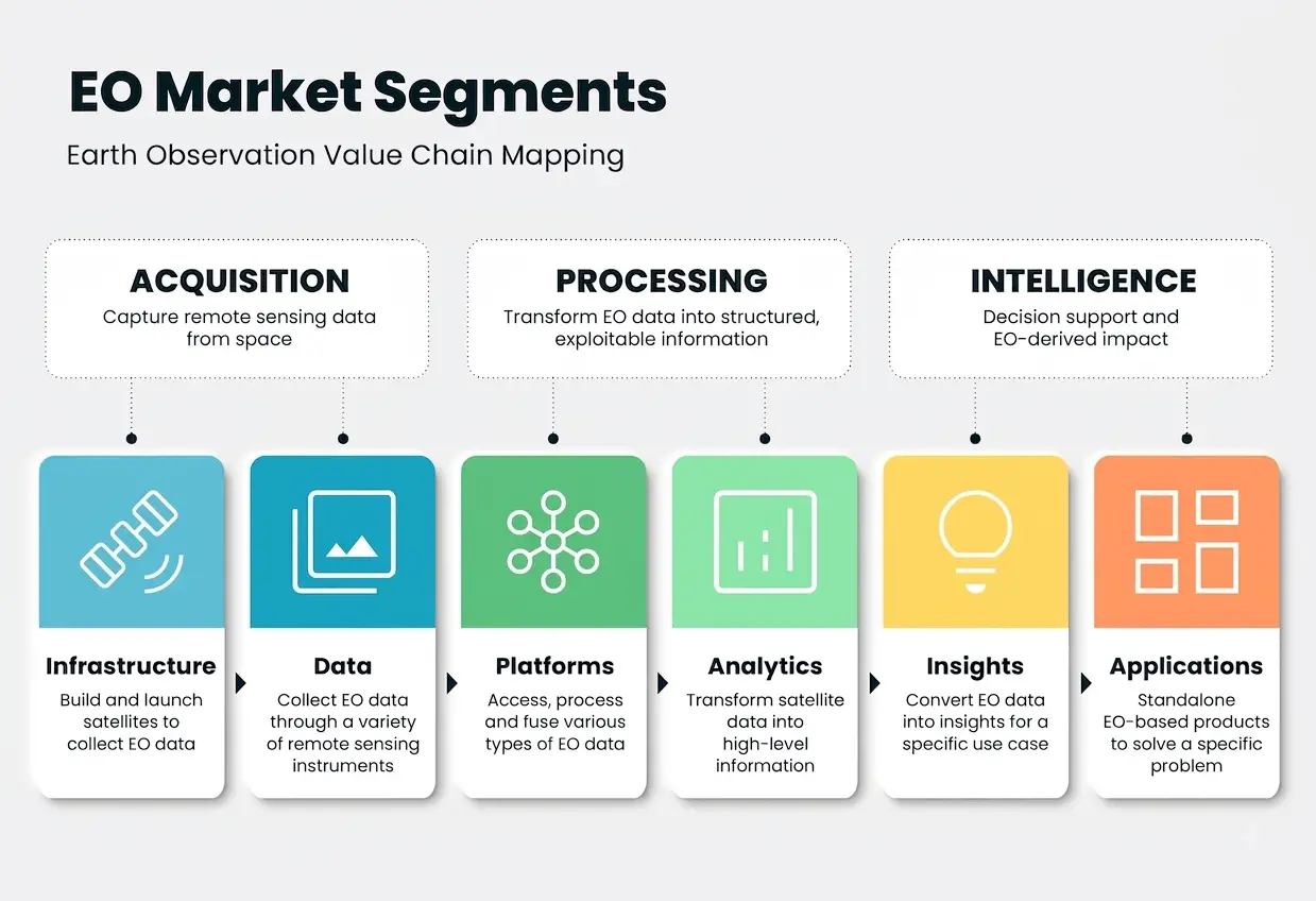
The three layers of the Earth observation chain
Understanding them illuminates the whole set of movements observed in the sector.
The sector analysis cited describes a layered organisation. It notes that the operator layer competes on sensor capability, revisit rate and contract access, while the aggregator layer competes on user experience and provider breadth.
The upstream layer of Earth observation comprises satellite operators, who own the acquisition means and sell access to their own sensors. Their advantage rests on the orbital asset and it requires considerable investment.
The intermediate layer comprises aggregators, who consolidate the offering of many suppliers behind a single interface. The same source specifies that those platforms allow customers to search, task and purchase data from 50 to 80 or more providers without maintaining separate contracts or technical integrations with each supplier.
The downstream layer finally comprises thematic service providers, who turn data into a product aimed at a particular sector.
One observation runs across those three layers and it matters. The same analysis notes that the data marketplace and data operator segments occupy different positions in the supply chain and that their interests do not always align, which explains part of the sector’s tensions.
The position of Earth observation operators
Their strategies deserve distinguishing, since they lead to very different needs.
A first Earth observation operator strategy rests on volume and coverage. Some operators run large constellations offering frequent revisit and a deep archive, which is a real barrier to entry.
A second strategy rests on differentiation by sensor type. Radar and hyperspectral specialists offer a capability optical constellations do not provide, notably the all-weather acquisition the opening article flagged.
A third, more recent strategy consists of moving up the chain towards decision-ready products. Sector analyses observe that operators are seeking to turn imagery into higher-margin products rather than sell scenes.
That third movement is the most significant for a data provider. Producing a decision-ready product requires models, therefore annotated corpora, which shifts demand downstream.
The role of Earth observation aggregators
This intermediate layer is poorly known and it has changed market access substantially.
The contribution of aggregators is simple: a buyer who would have had to negotiate with several dozen suppliers deals with one interface. Transaction cost collapses.
Three consequences follow for the Earth observation market. Access to commercial data democratises, a small player being able to buy a scene without a framework contract. Comparison between suppliers becomes possible, which increases pricing pressure. And operators lose direct contact with part of their customers, which explains the tension noted above.
One observation usefully completes that picture. Consolidation touches this layer too, the cited analysis noting that one of the principal marketplaces was acquired by a sovereign group, which illustrates the strategic interest attached to that intermediation position.
The competitive structure of the Earth observation sector
One characteristic surprises newcomers and it shapes supplier choice.
A competitive analysis notes that the market balances moderate consolidation with disruptive entry, the top five vendors commanding roughly one half of global revenue while more than 150 startups jostle for niche footholds.
That configuration is characteristic of a sector in the middle of a full recomposition. Established positions rest on heavy assets and long-term institutional contracts; entrants rest on technical differentiation and falling launch costs, a dynamic the constellations article examines.
Two practical consequences follow from that. The diversity of the offering is real and it makes supplier choice non-trivial. And the survival of many entrants is not assured, which is a risk to consider for a project depending on a single source.
The pressure of free Earth observation data
This fact structures the economics of Earth observation.
A free, massive and high-quality public resource occupies the medium resolution segment with high repetition. It makes selling comparable data economically difficult.
Three commercial responses to that pressure occur. Moving up in resolution, placing the commercial offering in a segment the free resource does not cover. Moving up in responsiveness, with taskable acquisitions and guaranteed delays. And moving up in product, already noted, selling an answer rather than an image.
A fourth response, counterintuitive, deserves flagging. The same analysis notes that several operators have each released free open datasets to expand adoption and inform analytics model development, whether those open datasets translate into sustained commercial revenue being an open question.
That fourth mechanism deserves particular attention. An operator releasing data free so that models are developed on its sensor type creates an analytics ecosystem dependent on its technology. That is a standardisation strategy rather than generosity.
Institutional demand in Earth observation
A substantial part of the market escapes ordinary commercial logic entirely.
Public administrations, environmental agencies, defence services and crisis management bodies form a clientele whose logic differs.
Three characteristics distinguish that institutional clientele. Contracts are multi-year and large, which provides visibility the commercial market does not. Sovereignty requirements condition supplier choice, a subject one article in this series covers. And the purchasing procedure is formalised, which lengthens timelines and favours established players.
That institutional clientele explains a good part of the stability of dominant positions. An operator holding long-term institutional contracts weathers a period of pressure on imagery prices more easily.
Consolidation movements
They answer three distinct logics that are worth separating before drawing conclusions.
Vertical integration, by which an upstream player acquires a downstream processing and services capability, seeks to capture margin across the whole chain rather than on data sales alone.
Constellation pooling, by which operators share access to their fleets, improves revisit frequency without further orbital investment.
Acquisition of intermediation positions, noted above, targets control of customer access rather than of the asset.
Those three consolidation logics converge on one finding. Value is shifting from owning the satellite towards the ability to answer a question, which mechanically shifts the critical competence towards processing and therefore towards training data.
Where value sits for an Earth observation data provider
The preceding findings have direct and fairly specific consequences for demand.
The first of those consequences is that demand comes from the downstream layer rather than from operators. A satellite operator sells imagery and does not necessarily need annotated corpora; a thematic service provider needs them continually.
The second is that the move up into decision-ready products described above increases that demand. Each new product requires a model, therefore a training corpus and an evaluation corpus.
The third is that operators releasing open datasets creates a particular demand: those datasets serve model development, and exploiting them requires annotation the operator does not supply.
The fourth is that institutional clients impose traceability and documentation requirements the medical cluster showed to be comparable, which favours a provider able to satisfy them.
Earth observation data pricing models
This dimension conditions access to commercial data and it is rarely explained clearly.
Four pricing models coexist and the choice between them depends on the intended use. Sale by scene, suited to a one-off need and expensive at volume. Subscription to an area, giving access to all acquisitions over a defined perimeter and suited to regular monitoring. Subscription to a volume, expressed in area or scene count, offering flexibility. And tasked acquisition, guaranteeing a capture on a given date over a given area, which is the most expensive service.
Two further factors modulate those prices. The freshness of the data, an old archive being worth markedly less than a recent acquisition. And the extent of the licence, internal use, redistribution and commercial exploitation not being priced the same way.
That second factor deserves particular attention in a project. A licence limiting use to internal purposes forbids delivering a derived product to a client, a constraint sometimes discovered late and which invalidates a business model.
The most accessible segments of Earth observation
A ranking by ease of commercial access serves better than a segmentation by technology.
The first of those segments is that of mid-sized thematic service providers. They have a recurring corpus need, a short decision cycle and no in-house annotation team.
The second is sensor-specialised startups, whose large number the cited analysis notes. Their need is acute and their means constrained, which points towards targeted rather than volume services.
The third is laboratories and research centres, whose need is methodological and whose budget is framed.
The fourth is large operators and industrial groups, whose means are real and whose purchasing cycles are long.
That hierarchy explains why a provider gains from starting with the first of those segments, where the ratio between commercial effort and probability of closing is most favourable.
The European specificity of Earth observation
A provider based on the continent has a real interest in knowing these four characteristics.
The free public resource there is a European programme, giving continental players native access and a familiarity others lack. That advantage is real and it is little exploited.
Institutional demand there carries a sovereignty dimension the article on that subject examines, and which favours suppliers established in the Union for certain uses.
The fabric of players there is dense and fragmented, with many specialised startups the article on startups surveys.
And regulatory requirements on data processing, whose general principles the medical cluster set out, apply here too as soon as a project touches personal data, which happens more often than expected in very high resolution imagery.
Those four characteristics together outline a favourable position for a European annotation provider: proximity to the resource, sovereignty requirements, density of potential clients and a mastered regulatory framework.
Earth observation signals worth tracking
They allow the market to be followed without depending on vendor announcements.
The rate at which commercial operators release open datasets, indicating the intensity of competition for the analytics ecosystem.
Rapprochements between layers, indicating where players locate value.
The evolution of institutional contracts, whose volume and duration condition the stability of positions.
And the arrival of new free public missions, each shifting the boundary between what commercial suppliers can sell and what the free resource covers.
What this market has in common and what is unique
Comparison with medical imaging illuminates the dynamics described above.
Three clear commonalities appear between the two sectors. Value shifts from data towards demonstrating a benefit. The scarce competence is not the model but the reference allowing it to be evaluated. And institutional clients impose traceability requirements favouring suppliers able to satisfy them.
Two major differences separate them, however.
The first concerns the data regime. Where medical imagery is scarce, expensive to obtain and legally constrained, Earth observation offers a massive free resource. The bottleneck is therefore not in the same place.
The second concerns the regulatory barrier. A medical device requires a certification whose weight the corresponding cluster showed; a geospatial product meets no equivalent, except in defence uses.
That comparison has a practical consequence. The sales cycle is markedly shorter in Earth observation, and product validation rests on a technical demonstration rather than a regulatory procedure, which makes the market more accessible and more competitive.
How to approach the Earth observation market
These findings translate into a commercial approach whose order of steps matters.
Identify the target layer first. A pitch designed for a satellite operator does not suit a thematic service provider, their needs being opposite.
Then learn the prospect’s application domain. The opening article showed that annotation conventions vary strongly between agriculture, insurance, defence and environment, and an interlocutor immediately senses whether their domain is understood.
Situate the prospect’s maturity. A startup developing its first model has a training need; a player deploying a product has an evaluation and monitoring need, a distinction earlier clusters established and which holds here.
And offer a scoping engagement rather than a volume. In a market where feasibility depends on data availability and ground truth, an interlocutor able to assess that feasibility contributes more than a price per square kilometre.
That last recommendation deserves emphasis. It moves the conversation from price to method, ground on which an experienced provider stands clearly apart from an executor.
What buyers actually ask
Five questions recur when an Earth observation service provider evaluates an annotation supplier, and preparing answers to them matters more than any pitch.
Do you know our application domain. The opening article showed nomenclatures and quality requirements differ sharply between agriculture, insurance, defence and environment, and a generic answer here loses the conversation.
Can you work at our resolution and on our sensor type. Radar and hyperspectral annotation differ substantially from optical, and few providers handle all three.
How do you build ground truth where none exists. This is the question that separates providers, since it is where the real difficulty of Earth observation sits.
What geographic coverage can you document. A corpus concentrated on one region caps what any model trained on it can claim, and buyers increasingly know this.
And can you handle point clouds as well as imagery. Airborne laser data is a distinct competence and holding it widens the addressable market considerably.
Those five questions are answerable in writing once and then reused. A provider who has prepared them is having a technical conversation while a competitor is still describing capacity.
Common errors of reading
These misreadings recur often enough that naming them is usually enough to avoid them.
- Taking a market size valuation for usable information.
- Comparing figures drawn from different scopes.
- Treating operators and service providers as one market.
- Ignoring the aggregator layer when analysing market access.
- Assuming free and commercial data compete head on.
- Reading the release of open datasets as a disinterested act.
- Depending on a single source in a sector with many fragile entrants.
- Neglecting institutional clients and their specific requirements.
- Addressing operators rather than the downstream layer with an annotation offering.
- Assuming value remains attached to owning the orbital asset.
- Discovering late that a data licence forbids delivering a derived product.
- Pitching operators and thematic service providers in the same terms.
The risk of a fragile supplier base
One consequence of the competitive structure affects buyers rather than sellers.
One consequence of the Earth observation competitive structure described above deserves drawing out, since it affects buyers rather than sellers.
A sector with more than a hundred and fifty entrants competing for niche positions will not sustain them all. Some will be acquired, some will pivot, and some will close. That is normal in a recomposing market and it creates a specific project risk.
Three mitigations apply to that risk. Prefer sources with substitutes, meaning a sensor type served by several operators rather than one. Verify that the licence permits continued use of already acquired data if the supplier ceases operations, a clause rarely read and occasionally absent. And build the corpus rather than renting the analysis, since a corpus survives its supplier while a subscription does not.
That third mitigation is the one relevant here. A project that has annotated its own corpus retains an asset independent of any commercial relationship; one that relies on a provider’s analytics output holds nothing if the provider disappears.
Read that way, building annotated data is not only a technical necessity but a hedge against a supplier base whose consolidation is under way and whose outcome nobody can predict.
A market that rewards specialisation
One closing observation ties the structural picture to a practical choice.
The diversity of application domains described here means that generalist positioning works poorly. Agriculture, insurance, defence and environmental monitoring differ in their nomenclatures, their quality requirements, their buyers and their purchasing cycles.
A provider covering all of them shallowly competes on price everywhere. One that holds real depth in two or three competes on understanding, which is a far better position given that the buyer’s difficulty is rarely the annotation itself but knowing what should be annotated and how.
That depth accumulates through projects rather than through study. Each corpus built in a domain teaches its conventions, its edge cases and its acceptable error profile, and that knowledge is the asset a competitor cannot acquire by lowering a price.
The practical implication is to choose two or three domains deliberately rather than accepting whatever arrives, which is a harder discipline than it sounds and the main thing separating providers who compound from those who restart with every contract.
What to take away
The Earth observation market presents a rare configuration: a commercial offering in permanent competition with a massive, high-quality free public resource that exerts persistent pricing pressure on the lower end.
Three readings emerge. The chain organises into three layers, operators, aggregators and service providers, whose interests do not always align, aggregators giving access to several dozen suppliers through one interface and collapsing transaction cost. The dominant response to free-data pressure is the move up into decision-ready products, which shifts value from owning the satellite towards the ability to answer a question and therefore towards training corpora. And the release of open datasets by commercial operators, intended to inform model development on their sensor type, is a standardisation strategy whose commercial return remains an open question.
For the dynamic feeding this recomposition, the article on constellations and NewSpace examines the democratisation under way. For the sector overview, the article on Earth observation sets the frame for this series.
To explore delivery arrangements, supported formats and applicable control mechanisms, see our dedicated page on geospatial data processing. And if you are developing a thematic product requiring an annotated corpus, let us discuss your project.


